Today it is back to GoogleEarth and looking for the Syrian WMD infrastructure for nuclear and chem/bio weapons. These three are all interlinked with one thing: phosphorus. Syria happens to sit on one of the largest phosphate deposits in the region with about 1/5 of all Middle Eastern phosphate showing up in Syria. Beyond fertilizer, phosphate is also a foundational precursor to chemical weapons (such as VX nerve gas and Sarin) and very handy in mixing up biowarfare ingredients. And one major added bonus is the Charkiet deposit of phosphorus in Syria: uranium.
Now a bit of searching found me this publication from USGS on phosphate deposits globally and their locations. And doing a Syria search I dutifully started to find and label each of those with a place mark. One of the things that must be understood is that some of this data, indeed I expect ALL of it, dates before the time of geopositioning systems and used the old geological concept: get the coordinates as close as possible, but don't knock yourself out for precision - anyone THERE can find it from that. Coming up through the last years BEFORE accurate positioning on the ground was known, that was the concept that went on in geology. Now, when one starts to actually plot these down, I did find a couple of oddities:
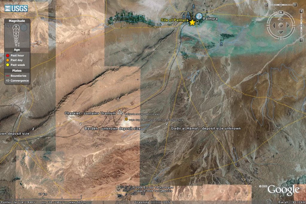
1) the Eastern A+B - Sawennah deposit region was *not* close to the Khneifiss deposits. In point of fact it fell within a residential area of the city of Homs. Well, I guess a transcribing error from notes or some such would explain that. And that will be left for another search on another day.Now I was beginning to understand why all the fuss for the Chinese reactor using phosphate based technology that went into Al Hajjar. So, after that, I plotted that and, like a couple of other places I noted phosphate mining going on.
2) One site of the Charkiet formation has uranium in the phosphate.
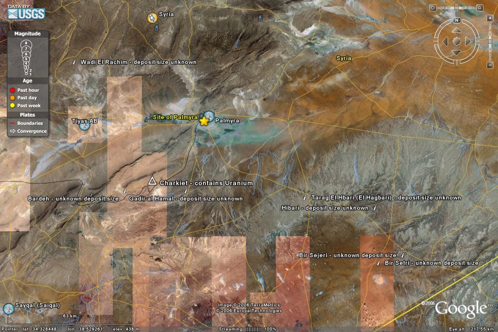
And I used a different symbol for the Charkiet formation. Note the large mining operation going on nearby it and keep in mind my earlier reference on personal knowledge of geo-mapping in the pre-GPS era. In fact, lets take a closer look at it!
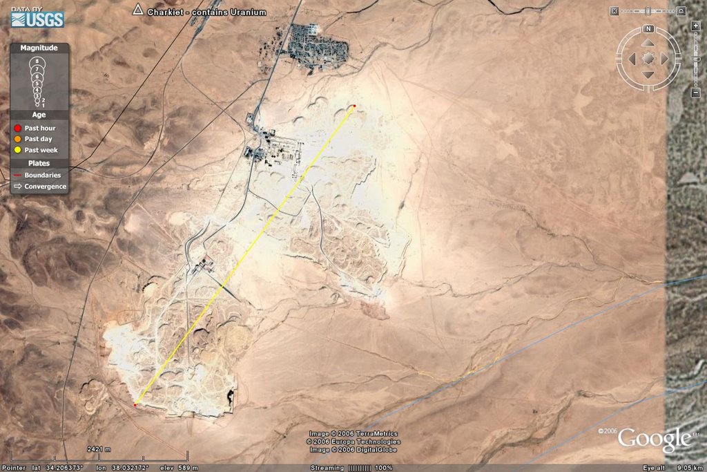
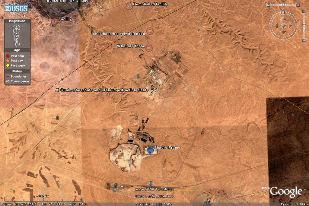
And I did the measurement with that line you can see and it is about 5 km long and the width is about 2.75 km. That covers the mining area itself, not the image. And with so much phosphate laying around that really must be a phosphate mining/processing plant in amongst all the phosphate. To make sure I wanted to find what *another* phosphate plant looked like and so I found the Iraqi Al Qaim plant at GlobalSecurity.org, which has all sorts of lovely imagery like this:

And here is what GlobalSecurity.org has to say about Al Qaim:
Al Qaim engaged in the production of yellow cake (refined uranium ore) from 1984 to 1990. All of the yellow cake used by nuclear program allegedly came from this site. Ore was supplied to the facility by both Iraqi and foreign sources.And from what I have read of the 'Palmyra facility' in Syria, that estimate of 300,000 tons/year for Al Qaim is a bit low and expansion to the full 1,000,000 tons/year dead on as that is what Syria is doing by opening up a processing plant in Aleppo. Now, since everyone knows about Al Qaim it has been widely looked at in GoogleEarth and here is the picture of it:
Al Qaim is said to be located 380 km WNW of Baghdad. One of two towns named Al Qa'im is not located in the reported WNW direction from Baghdad. The Al Qa'im tower [variants: Manarat al Qa'im; Imam Ilkaim] is located in roughly the correct direction. The other town of Al Qa'im [variants: El Qa'im; El Kaim] is located roughly in the correct direction from Baghdad. The plant itself is located somewhat to the southeast of the town of Al Qaim.
Phosphate rock reserves were located mainly in the Akashat area northwest of Baghdad and were estimated in 1987 at 5.5 billion tons -- enough to meet local needs for centuries. A fertilizer plant at Al Qaim, linked by rail to the Akashat mine, started production in 1984; it was soon converting 3.4 million tons of phosphate per year into fertilizer. As the Al Qaim operation came onstream, Iraq became self-sufficient in fertilizer, and three-quarters of the plant's output was exported. Iranian attacks on Iraqi fertilizer plants in the Basra area, however, cut Iraq's surplus. In 1986 Iraq obtained a US$10 million loan from the Islamic Development Bank to import urea fertilizer, and in 1987 Iraq continued to import fertilizer as an emergency measure. Meanwhile, additional fertilizer plants were under construction in 1987 at Shuwairah, near Mosul, and at Baiji. Their completion would bring to five the number of Iraqi fertilizer plants and would increase exports considerably.
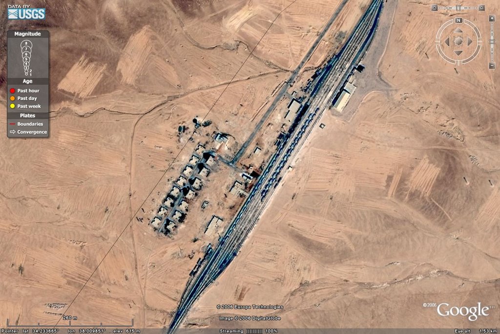
Yes, well gone over, but good for reference along with the UNCLASSIFIED imagery from DoD. So we now have two wonderful references to use for that one near Palmyra. Here is a close-up of that plant in the formation near Palmyra.

Now that upper area part of the plant is about 0.75 km by 0.5 km, and the lower one is about 0.2 km on a side with that extra part about 0.1 km by 0.2 km. The main difference between these plants is that the Iraqi one contains the mining while they Syrian one sprawls all over the place. And the part of real interest is just to the NE of the main plant, right on its corner:
It is undergoing EXPANSION into an area about half the size of that main facility. Yes that is all piping, conduit and such like, plus what looks to be the expansion outlines and a first building already up. The production ability of this plant, then, has not even been reached yet, and by looking at the size of the deposit they are working, will not be reached for years. Now, just inside the main part of the plant that has a rail line going through it, I found something in the NW part of the main facility that will put this entire place into perspective.

As the placemark indicates THOSE are two tractor-trailer tanker trucks with the trailer about 10m or so in length. So that begins to get the scale of this place down. So I will label the plant and a nearby rail line that looks to be an on/off load area for trucks. A group of buildings looks to be bulk storage, to my eyes at least, and the ones behind the main rail yards are questionable, too. Possibly residential, but really unknown.
Now, why is this important? For that takes a quick visit to the Nuclear Threat Initiative site and their review of the Nuclear Facilities for Syria, particularly the one for the one near Palmyra:
Nuclear FacilitiesNow that is pretty highly technical, isn't it? With that we can start to work out the actual amount of uranium being processed out of this area. Starting with the parts per million which is the milligram per kilogram of mass (mg/kg). Thus this is 60 - 80 mg of uranium per kilogram of ore. In metric the 1t (tonne) is 1,000 kg (or 1 Mg), which means that the concentration is 60 - 80 grams of uranium per 1t of ore. The current amount being processed by this plant is 2,65 Mt of ore/yr, which means you get 159 - 212 Mg of uranium ore per year. As the average of U-235 is 0.72% of any average uranium ore which comes out to 115 - 150 kg/yr. And from a site looking an Nuclear Chemistry, we get the AQ Khan or similar modern nuclear device will use 25 kg of uranium that is 90% or more of U-235.
Deposit No. 1184
Other Names: Eastern A and B, Sawwaneh
Location: Sawwaneh, 45km southwest of Palmyra[1]
Subordinate To: n/a
Size: n/a
Primary Function: Phosphatic rock mine
Description: Phosphorite mined at the Deposit No. 1184 is bedded, both hard and soft phosphorite of late Cretaceous era.[2] The Sawwaneh phosphatic rock contains about 60 to 80 parts per million of uranium.[3] The General Company for Phosphate and Mines (GECOPHAM) mines the deposits, and the combined capacity of Eastern A, Eastern B, and the Kneifis phosphate rock mines is 2.65Mt/year.
Count that as an average of 5 weights of uranium to make nuclear devices per year, but some lost to processing and such.
Now, over to Homs to look at their petroleum refinery.

Luckily a kind soul had already identified this during my major scraping of the GoogleEarth and Keyhole BBS systems. So it was easy to find. Identifying the chemical part of it, however, takes some doing as it is variously described as: underground, adjacent and within the actual complex. I have looked at the possibilities for an underground facility. A bit of interest is that the Swedish company that made the facility, MEAB, also has a nice picture of it, all tinted and such, to make it difficult to figure a few things out.
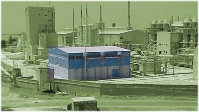 MEAB SAEC plant Homs, Syria
Yes, your guess is as good as mine, here.
If it is *in* the facility as the photo suggests and others have, then that tank farm arrangement in the background is not present at the petrochemical plant.
If it was dismantled and moved, the outline of it, based on the amount of work to put it in place, would still be visible. Even if they pulled a 'Carthage' on it and then built on top of it, that basic outlines of the differences in tonal quality would still be visible.
Do note that Syria has not repaired the battle damage on some of the buildings in the Homs petrochemical facility for decades... so making them the neat and tidy sort necessary for the above two is a bit out of line with how they run things.
If it was buried there would be a hill with some sort of representation of vents and such over it, and not much on the hill itself. That is not present in this very flat area of Syria.
It is there *someplace*.
And that place is NOT in Homs but in nearby Kattine. I will come at this on the oblique and then in the plan view and with the items of similarity pointed out. Some changes have taken place since the Swedish photo, but the actual facility itself is hard to disguise.

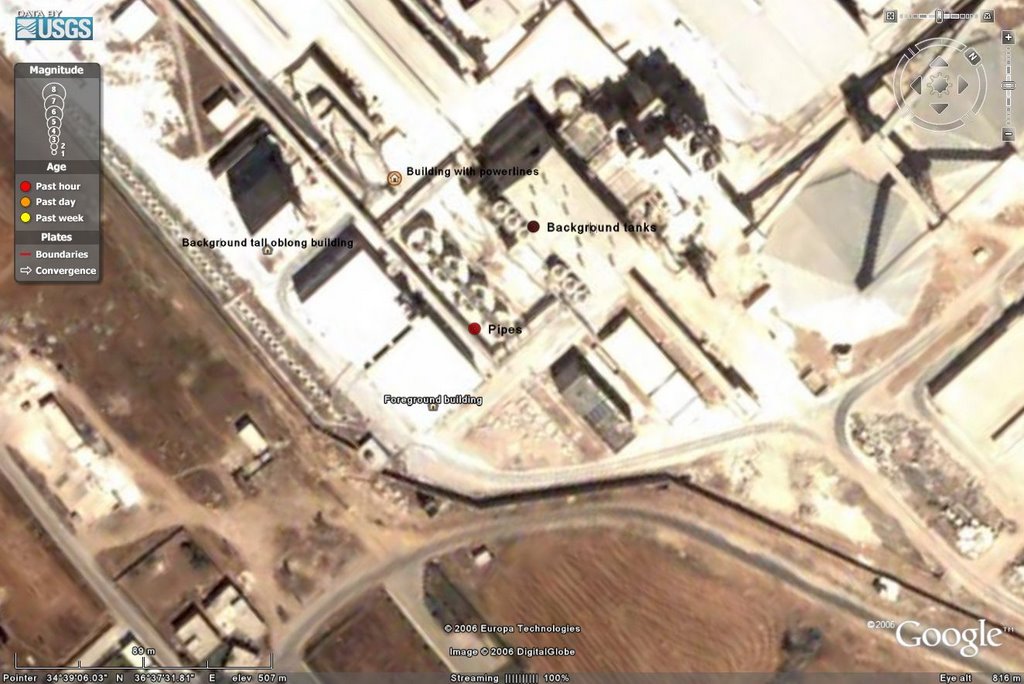
Here are the points of correspondence:
1) The Foreground building corresponds to that seen in the MEAB photo. Note the diagonal wall and structure in the wall as well as the square structure just outside it, and the building just across the street which is in the very bottom of the MEAB photo. Five points of similarity.Taken together there are 17 points of similarity with only one dissimilarity being the building behind the Foreground building being as high as it. That is not enough to take this site out and the overwhelming similarity points to this as the SAEC plant in Homs. I will not try to tell you how long that has taken to find this plant!
2) The piping just to the right of the Foreground building. Also low cylindrical tanks there. Piping connecting the tanks. Three points of similarity.
3) The upright oblong building on the left of the MEAB photo. And the space between it and the building with power uprights. Two points of similarity.
4) To the far right of the MEAB photo is a tank complex, separated with a building just before the separation and a building just behind the tanks. Four general points of similarity if all of the tanks are taken as one similarity and not by tank.
5) The center back of the MEAB photo has a building with power uprights, a building behind it and one more to the right of it on the photo. All of the parts behind that building with power uprights is now seen as one building behind it, which is obscured in the photo. Three points of similarity.
Well, those were the two major sticking points to find. The Charkiet formation phosphorus plant produces at the rate of 60-80 ppm and has a facility doing 0.5Mt/y. But that will wait for another day as I slowly remove all the Westward sites and move east into less well talked about areas.


 Supporting Friends and Allies


4 comments:
Wow, that's really technical and painstaking work. I applaud you for your efforts.
And I didn't know Google Earth was that precise.
Harrison - Not even the half of it... I had already found the previously mentioned underground chemical warfare facility and attendant base previously. Before that how to place a basic overlay of map or image. Starting it all off was this post on the basics.
So much fun! And a useful way to waste time, too...
Dear Sir: you need to get paid for this. Very interesting work connecting all the dots. I hope the people who work for the our state department are half as smart as you are.
Serendip - That is my life past, now. I am no longer well enough to work at that... but *play*? When my mind cooperates, yes.
But for me this is all just to learn about the WMD facilities in Syria so I can start to typify them and look for similar in the Eastern part of the country. I am not enthused based on the imagery and Deir al-Hajar, however. The GE imagery starts to get cruddy just where I want to look, so it will be getting other sources and overlays and all sorts of fun things.
And what really gets me is that this is all open source! Just to gather these materials a decade ago, would have been weeks, if not longer, just for a little bit of this. Absolutely amazed at what is out there... Anyone can do this! Well, anyone who enjoys eyestrain and headaches, at least.
But then, I do have a strange definition of *fun*.
Post a Comment