Everyone loves a good disaster! Just look at the 1970's movie line-up and you get a sheer plethora of star-studded disasters, and many of them from Irwin Allen... so it is the IA decade: The Poseidon Adventure (the original with Gene Hackman), The Towering Inferno, Flood! , Fire! , The Swarm, Beyond the Poseidon Adventure (but why?).
And then others joined in to show that Mr. Allen really *was* the Master of Disaster: Earthquake (when this was up at the same time as The Towering Inferno for *weeks* it was "Shake and Bake"), The Andromeda Strain, Disaster on the Coastliner, SST: Death Flight (ahhh... nostalgia! but it does feature a contagious flu), Encounter with Disaster (which goes over some real-life disasters), The Hindenburg, Airport (and its sequels 1975, 1977, The Concorde 1979), Flight to Holocaust (private jet collides with 20th story of high-rise), The Buffalo Creek Flood: An Act of Man (mine disaster retrospective), Dark Star (one of the best low-budget satires of its kind and the novelization by Alan Dean Foster is even better!), Nippon chinbotsu (aka. Tidal Wave), The China Syndrome, Bug....
Yes, apparently movie goers just wanted to see destruction, mayhem, fire, disease, floods, and all sorts of things that *could* be going on but weren't. And this lovely time I also like to call the Decade of Innocence for Disasters, because, really, the world was quite a calm and placid place for so many decades... the last of the Little Ice Age finally leaving after the dust from Krakatoa settled, a few tidal waves from earthquakes here and there, the odd earthquake in California and other parts of the world, maybe a swarm of locusts... but, really, things were quite quiet. Thankfully, geologists were about to make all of those disasters seem miniscule in comparison to what the normal process of the Earth's surface and environs actually *does*.
So, some background on our planet. Earth, if you check the link is 4.2 - 4.5 Billion years old and in its early stages it was forming as a nice, kind of small planet which was going on its merry way in orbit slowly building up material to be a sedentary kind of planet. Unfortunately there was another object that was about the size of Mars that was being perturbed in orbit and it finally collided with the Earth causing a splash and deep melting of the whole shebang. Earth got lots of new material and the detritus in orbit coalesced into the Moon. From there gravitational gradients of infalling material helped melting to occur, then pressure as the various parts of the planet contracted and compacted caused more melting, until heavy metals with radionucleotides seeped their way into the center to form the solid core. Then things heated up and the entire differentiation process speeded up as the heat from all of this tried to get out. It took a few million years for the crust to finally cool enough to start to form into solid pieces, which were still churned about until the outer layer finally solidified. Over the next few hundred million years tectonic plates were formed and they moved in accordance with those heat flows which had upwellings from the sub-surface structure of the planet.
Now, if you check out the nice little wikipedia article, it gives you the thumbnail sketch of the entire process, which is more than enough to get your feet wet. And if you don't like their description then imagine a vast vat of slowly cooling chicken soup with it cooling enough to let the lighter, more fatty stuff float to the top and form a layer. Keep the vat on LOW and you will slowly see patterns of deformation and breakup on the surface due to the upwelling of material that has been heated and less dense coming up from the bottom. Turn that into a sphere with its own heat source from a huge, dense rock in the center and you have an idea of the entire structure of the planet Earth, save no chicken bits or vegetable material roaming around in it. Oh, and the part we live on? On the soup pot concept we all live on that 0.01mm on the very surface.
Perhaps not a pretty picture, and I am sure someone can come up with custard or gelatine or some such to give a better representation of it. Those have a much better consistancy than chicken soup and would do far better to demonstrate actual plastic flow of material, but somehow letting custard get a crust and then heating it just isn't a pleasant picture. Sorry to have brought it up! And as a technical side note, when one speaks about "The scum of the Earth" that is, technically, the crustal material. And as all of life *exists* on that crustal material, well, to put it politely we are things that live on scum. So calling someone 'the scum of the earth' might be seen as an inadvertant elevation to a far higher position than one is deserving of having... to a geologist at least. So don't let yourself get into a shouting match with a geologist who thinks you are elevating someone above their place when, in fact, you are doing contrary-wise.
So, back to plate tectonics! Now the actual plates of the Earth move so slowly that no one really knew they moved at all... actually, no one even knew that there WERE plates of crustal material until the theory of it was put forth in the 1960's. Now I go into the background of that in this posting, but suffice it to say this has been nailed down as the way the Earth actually works. The entire theory now covers all the known effects of earthquakes, tsunamis, volcanic activity and orogeny. From magnetic orientation of seafloor material to stationary hot spots and moving plates, this takes care of why we have the geophysical features and structures that we see today and has been further backed up by seismic readings, deep magnetometer readings and measuring what is moving on the Earth by actual measurements.
Nothing, and I do mean *nothing* else explains the entire system as a whole. Further, as it is a predictive theory, we can take a look at the features left by past events and try to figure out why they happened. And it is a big, big shock to people when something like the Indian Ocean Earthquake of 2004 happens and the effects of it can be seen across the planet as the rotation of the planet changed slightly, as taken by distance and timing measurements via laser reflectors left on the Moon. Things like this may have a low periodicity rate compared to human life-spans, but are quite frequent and ongoing in the geological record. Thus, being predictive, geology tries its hardest to understand how the entire planet, from core to exosphere and beyond, works as a system. And by doing so the most disasterous of disasters can be gauged and their periodicity given by looking at sedimentation, tree rings, varves, ice cores, seafloor sediment cores and actual rock.
With that we can now see the top 5 disasters for North America! And you thought the nasty stuff had been stuck in the '70s, didn't you? So in reverse order, here are, as I see them, the top 5 pieces of nastiness that could happen tomorrow or 1,000 years from now or more... but they *will* happen based on physics, chemistry and radioactivity. And there is very, very, very little that mankind can do about ANY of them.
Oh, I doubt you will find *these* on the FEMA contingency plan listing.
Number 5 : The 'Big One' for California
Earthquakes, both big and small in California, have a periodicity to them that is pretty well known from sediment analysis and the human record. A Pacific crustal plate (and there are a number of them) is sliding to the north and a bit west relative to the North American plate. The most famous of these contact zones is the San Andreas Fault, which grinds along in a motion that is erratic, but predictable in average period. Actually, by giving release to energy so often this fault not only makes itself plain to understand but also saves us from having to worry about huge releases of energy built up over centuries. So, Southern California should consider itself lucky to have such a nice fault! As these things go, at least.
This type of fault, being a sliding motion between plates, with the pacific plate heading to the north and west relative to the north american plate, is, actually, not so bad. When the pacific plate hit against the north american plate, the ocean between the two plates, being less dense than the oceanic plate, tended to get scraped upwards and into the state we call California. This material is still quite saturated with water and tends to act as a giant shock absorber for earthquakes, thus they do not propogate that far outwards from their initial epicenter. So what happens in California *stays* in California, although Nevada does get its small share of the energy but nothing like the actual fault zone itself has. Marin County has a nice summary of some of their local features, but this entire concept plays out all along south coastal and central California. I remember one geologist looking at San Francisco and identifying rock and features typified of over 60 different geographical regions and ocean floor types and saying: 'This part of California appears to have been a global tourist before coming for a visit here.'
Now, as the good folks at USGS have looked at the fault, we come up with this little observation:
Along the Earth's plate boundaries, such as the San Andreas fault, segments exist where no large earthquakes have occurred for long intervals of time. Scientists term these segments "seismic gaps" and, in general, have been successful in forecasting the time when some of the seismic gaps will produce large earthquakes. Geologic studies show that over the past 1,400 to 1,500 years large earthquakes have occurred at about 150-year intervals on the southern San Andreas fault. As the last large earthquake on the southern San Andreas occurred in 1857, that section of the fault is considered a likely location for an earthquake within the next few decades. The San Francisco Bay area has a slightly lower potential for a great earthquake, as less than 100 years have passed since the great 1906 earthquake; however, moderate-sized, potentially damaging earthquakes could occur in this area at any time.So, the 1906 San Francisco Earthquake and subsequent fire is on a section of fault that does stick somewhat and, while the fault as a whole has a periodicity or average recurrance time of 150 years for large earthquakes that is just an average with a range not well understood. The folks at the California Geological Survey are, of course, keeping a strict watch on this and the more southernly portions of the fault. And that is the worrying section as that southern fault zone last went in a big way in 1857 and has a 150 year periodicity, which makes it due in our immediate future and, as this fault has seen a constant rate of slippage given its underlying geology, no more than 200 years as an outer time horizon. That last is, of course, a guess.
A great earthquake very possibly will not occur unannounced. Such an earthquake may be preceded by an increase in seismicity for several years, possibly including several foreshocks of about magnitude 5 along the fault. Before the next large earthquake, seismologists also expect to record changes in the Earth's surface, such as a shortening of survey lines across the fault, changes in elevation, and effects on strainmeters in wells. A key area for research on methods of earthquake prediction is the section of the San Andreas fault near Parkfield in central California, where a moderate-size earthquake has occurred on the average of every 20-22 years for about the last 100 years. Since the last sizeable earthquake occurred in 1966, Parkfield has a high probability for a magnitude 5-6 earthquake before the end of this century and possibly one may occur within a few years of 1988. The U.S. Geological Survey has placed an array of instruments in the Parkfield area and is carefully studying the data being collected, attempting to learn what changes might precede an earthquake of about that size.
So, what could be in store for California in the near future? First a good sized quake near the Fort Tejon area in the vicinity of magnitude 8.0... with a range most likely between magnitudes 7.8 and 8.2 for a rough guesstimate. The area is not my specialty, but the range sounds likely given slippage build-up and probably length of fault to move. A repeat of the San Francisco earthquake between magnitudes 7.5 to 8.0 would also be expected in the up to 50 year time horizon, although it may be longer or shorter than that. Actually, the more frequent the earthquakes the smaller the magnitude as the energy gets released more often.
For the Fort Tejon type of quake, Los Angeles could probably expect to feel a quake between 6.8 to 7.8 depending on where, exactly the fault starts to slip and how much of the fault actually does slip. And for this type of fault the longer the slip the higher the magnitude of the quake. Some parts of this fault have not slipped much or at all since 1857 so a long boundary slip would be expected which puts the quake itself in the higher magnitude range.
San Francisco would take the brunt of the quake just outside of downtown and experience it heavily throughout the region. Again, large sections of the fault zone have been quiescent with little release of energy since 1906, and nearby fault zones do not, necessarily, relieve strain on the main fault.
The central portion of the fault slips relatively smoothly and seems to shift relatively easily given the pressures it is under. What the exact dynamic of a Fort Tejon area quake suddenly shifting to catch up with this central portion is not clearly understood. First, would this movement cause a dynamic shifting along the fault zone or would it suddenly lock up? Either of these is troublesome, it would seem to me:
- A dynamic shifting of movement, while nice for that section of the fault, would transfer energy quickly to the northern section running through San Francisco, which suddenly puts much, much more stored energy into that zone. And here 'suddenly' to a geologist is something under 10 years, just so we have the time scale right. So monitoring of that central fault zone would tell much about the energy dynamics of the northern zone. From that the northern zone quake might push up one entire magnitude on the open-ended Richter scale and thus have 10 times the energy released. Thus a magnitude 8.5 to 9.0 earthquake is not out of the question if the southern zone moves first and its energy is dynamically transferred north. This would be a short and intense earthquake, probably not more than 30-40 seconds in length.
- If the central zone suddenly locks up, then the entire stored energy of shift from the southern zone pushing into it becomes stored potential energy which could then trigger a very long release once the northern zone shifts. Now there may be enough dynamic separation between north and central so that an earthquake in the north does *not* also include the central zone. That would be a *good* thing, limiting the size of the north quake to 7.5 to 8.0 and lasting 30-40 seconds. If, however, it does slip with the north, then the entire length of north and central release stored energy for a 8.5 to 9.0 earthquake lasting 45 seconds to 60 seconds. A nasty shock to say the least.
Of much greater worry is the lack of a redundant emergency water supply system to fight fires. Even if emergency responders can *get* to a fire, the broken water system will not allow for the fire to actually by contained. Some efforts have been put into sea water emergency lay-down systems, but those have pumping limitations based on the amount of pipe, width of pipe, number of pumps, energy supply and uphill gradient. And while modern concrete, glass and steel buildings are likely to survive the initial quake, they may come to be very susceptible to surrounding fires and the lack of ability to control internal fires on independent systems for more than an hour or so. With large unreinforced masonry building sections in both municipalities and a large amount of wood frame construction, these areas are tinderboxes without fire suppression. Fires starting from ruptured gas mains, ruptured fuel tanks and masonry buildings having their contents catch on fire could see something the equivalent of a firestorm happen in the days after a large quake in either metropolitan area.
About the only thing to be really thankful for is that such quakes rarely cause tsunamis! That would really cause problems on the coast...
Number 4 : Cascadia
(Image Courtesy: Wikipedia)
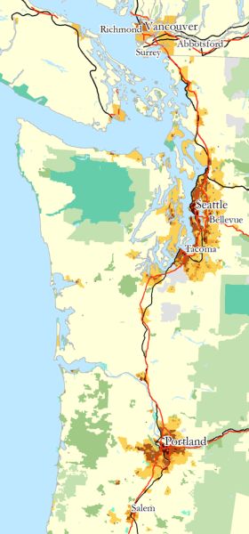 Ahh, the scenic Pacific Northwest! Lovely coastline! Beautiful forests! Scenic mountains! And volcanos, earthquakes and tsunamis... not that those latter are seen in tourist brochures. The region from northern California all the way up into Canada... Cascadia! And to a geologist this means the Cascadia Subduction zone and its attendant earthquakes and tsunamis. In this region, off the coast, the Juan de Fuca sea floor plate, which is somewhat trapezoidal with the large end being subducted under the North American plate, has been merrily doing so for millions of years. We know this from the volcanic activity attendant to the plate as it melts from friction and subsurface heat and pressure under the North American plate. It has formed the Cascade range of mountains and volcanos. Yes, *something* has to build that wondeful scenery and here it is the geological forces of plate subduction giving lovely volcanos to help dot the landscape and transform it into something truly awe inspiring... and very much so when one releases magmatic pressures under it!
But those are *not* the worry from Cascadia... instead the megathrust undersea fault is the primary concern here as they can cause severe earthquakes and tsunamis. This is the equivalent of the Indian Ocean Earthquake but happening right off the Northwest coast of North America. The last time that the Cascadia subduction zone caused one of these events was on January 26, 1700. This was figured out by a process of narrowing down the time frame for some event or events that had happened along that coastline that had left some very strange artifacts. The primary one being the Ghost Forest of Washington State which showed evidence of massive forest damage in the past, subsidence and then slow uplift over time. The uplift is caused by the locking of the North American plate on the Juan de Fuca plate as the latter moves 44 millimeters a year towards the North American plate.
Now, being locked together like that means that the edge of the North American continent gets slowly pushed upwards. This stores the energy of movement until it catastrophically lets go, and when it does it is usually along the entire fault boundary at one shot. And the last time the Cascadia went in 1700 the land subsided along the coast, allowing water to rush in and that was followed a few minutes later by the tsunami caused by the quake. The year was pinned down by using tree rings and matching them against known tree rings to get an approximate date... which was right after the 1699 tree ring was formed. Once this was known, then consulting with local Native American's confirmed stories about the Thunderbird letting loose and great waves hitting the land. Brian Atwater looked for something more specific, however, and found it with the help of researchers in Japan going through old monastic records which recorded an orphan tsunami, its height and the day and hour it struck at. By backtracking the known wave travel time you get to the exact date and nearly the exact hour and minute it hit.
Now the periodicity for the Cascadia is 500 years, but its range is 300 to 900 years, with sediment work pinning down multiple quakes to give us this range. A quick check of the calendar and we see that we are now within the Cascadia range. So, what exactly has built up over the last 300 years?
First, the Juan de Fuca plate has put in 13.2 meters of stress on the North American plate edge, which is the equivalent of what was released during the Indian Ocean quake. So, when Cascadia lets go, we can expect to see a similar occurance along that region that was seen near the fault in the Indian Ocean.
Second, the shoreline, by being uplifted has allowed for construction of all sorts right along the coastline.
Third, and finally, by not experiencing frequent quakes in the Pacific Northwest, the cities there do *not* build to earthquake resistant codes.
What happens when Cascadia goes? A magnitude 9.0 quake lasting for up to 5 long minutes. Now as the Cascades and coastal range mountains are generally uncompacted sediment, they will, like in California, act as a shock absorber to vibrations. And, since this is a localized land subsidence on the edge of the plate via the megathrust it should not be heavily felt beyond the immediate coastal regions. From the coast up to the coastal range of mountains, however, this will be felt with severity increasing towards the coast. Those directly on the coast will feel it worse and may experience a sudden inrushing of the sea as that part of the plate subsides. Not a good day to go swimming.
Nothing has been tested under such stress, even buildings built to California code, so no one knows exactly what will and will not survive such a quake. Unreinforced masonry buildings will collapse, and there are a plethora of those along all the cities on the coastline there. So if you are in a brick building, you may experience sudden building failure. Steel girder construction structures should fare relatively well, with swaying and some nausea for occupants. As a megathrust fault has a different mix of wavelengths and types that are sustained, some structures may experience failures when very long wavelengths play through them for endless minutes. Really, as we have no record of this type of wavelength mixtures sustained for this length of time, no one knows. And as in California, the largest immediate problem will be fires and disruption of utilities and the breakdown of the highway system, including bridge and skyway collapses. A major oil pipeline from Canada runs through this region and will also be disrupted as it suffers mild to moderate quake damage along its entire length and severe damage on the coast by Vancouver, B.C. and Seattle-Tacoma, Washington. There is a good chance that the coastal region of Cascadia will fall off the power grid and cause power re-routing and blackouts. This is less of a concern in California as their grid knows how to deal with sudden drop offs due to quakes, while the rest of North America does not. Most dams should fare well, save those that are on major rivers and may experience backwash of water due to oceanic flow upstream due to subsidence. California does not have this to worry about as it is a lateral fault not a megathrust fault. The population density, being more coastal, will put a population of approximately 7 million people at risk in the major metropolitan regions, with a smaller and more dispersed number along the entire coastline.
And then, as if a magnitude 9 earthquake lasting 5 minutes and a meter or two of coastal subsidence isn't enough, 10-15 minutes later a 13 meter high tsunami hits the coast! To anyone living on the Pacific Coast of Cascadia, from Northern California to Northern British Columbia: if you are within 3 miles of the coast run, do not drive, as fast as you can away from the coast and/or uphill. It *will* save your life. Do NOT stay on the coast and gawk, if you do you will die. This includes all of Western Vancouver Island. If you are on the Eastern Coast or in the Puget sound I will say that past wave forms are not a great predictor for future tidal waves. Seattle, in particular, has seen tsunami wash along its coastline and I would not want to predict what the reflection and refraction of waveforms will do along the coast. The sea is *not* to be trusted.
If you are in the MegaCity area, especially near the coast or on the banks of major rivers *including* Portland along the Willamette River get *away* from them. You are not safe and past wash sediment deposit indicates the tsunami has pushed backwater all the way to Portland, Oregon.
Tsunamis are multiple wave forms and the first is usually *not* the worst. In the Indian Ocean Earthquake it varied from the second wave to the fifth wave coming in being the most deadly. A tsunami is a front of water that stretches across the entire coastline to the extent of the fault and spreads as it heads to land and can be up to half a mile deep and as high as the megathrust event. Starting with current conditions that is 40 feet high and half a mile deep across the entire coast coming in multiples ranging from 5 feet at the lowest and 60 feet at the highest due to land constriction of waveforms. And the water from a previous wavefront will not have drained before the next one comes in to push the first farther inland. Tsunami's can typically have 20 minutes to 90 minutes between waves. You are not safe until 10 hours have passed. It is very tempting to go and try to rescue people after wave 3 or 4... if you do, you may be on the casualty list. No one can predict ahead of time what the number or severity of waves will be and it varies across the entire fault and coastline.
A 5 minute magnitude 9 earthquake is *not* a drill. It is the real deal. If you can survive the quake, get high enough to wait out the tsunami and then *stay put* until the last of the waves have left and the worst of the collapsing of buildings is over, then you can think about what to do next. I suggest heading inland for help and organization. Others will rush into the disaster area unprepared... that is your right to do so and your life is in your hands as rescue may be hours or days or weeks away.
This is why this event tops the 'Big One' for California: The US and Canada are wholly unprepared for this sort of devastation and we have not built with it in mind. This will be a nasty event until the entire infrastructure of the Cascadia region is re-made to handle it. And some things we can *never* prepare for.
Number 3: New Madrid
(Image Courtesy: USGS)
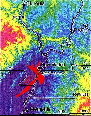 Welcome to the Heartland of America! Where the mighty Mississippi flows and good sized cities flourish and earthquakes are rare and deadly. This is the land where the United States experienced its worst earthquake in its short history. Here, between December of 1811 and February of 1812 three earthquakes close to magnitude 8 or more (we don't really know as we have to infer from observation data and not seismic records) rattled not only through the Heartland but rang church bells in Boston, Massachussets and shook Quebec City so that dishes rattled. These quakes and their over 2000 smaller aftershocks ranging from magnitude 3 to 6 made life very uneasy. To understand *why* we must look at the entire zone as a whole and its history. Luckily, the folks at the US Geological Survey have done this for us! And the folks at Wikipedia have also done a good job on the basics.
So let me set the scene at 750 million years ago.
The Earth had cooled and continents had formed and water was in its basins and life was emerging into various and splendiferous forms, radiating into all sorts of strange and interesting designs. The Supercontinent of Rodinia, however, was feeling internal pressures and started to break up into smaller continental forms. Many large and grand rift valleys formed, but not all of them would herald the splitting off of a continent. In the middle of what we know as the North American plate a rift valley also formed, but it was destined not to be one that spread and connected much. Over a few million years it subsided in activity and the plate of North America remained intact, save for this tear where the rifting had started. So by 500 million years ago things had calmed down and the plates started on their merry way of colliding, subducting, producing mountains and volcanic regions and things were *good*. Well, speaking for the crustal portion of the planet, that is.
Continents drifted, life evolved, spread, did all sorts of interesting things, life died out leaving few survivors a few times and things just kept on happening. Life, even conscious life of the last few thousand years, didn't really pay much attention to such things as earthquakes. With the coming of civilization to the shores of the Continent and a very young nation still not well settled, this strange and long series of earthquakes were just something that happened. Unless one was in the zone of them, in which case you were absolutely convinced the Earth was ending.
The thing that drives the energy for this fault is the North Atlantic Spreading Center along the Mid-Atlantic Ridge. Yes, the problems here start at sea, as so many things in life do. The Atlantic seafloor spreads out from the ridge at a slow, but stately 5-10 cm per year. The North American plate is pushed by this and, since it is the direction it wants to go, subduction does *not* take place. Unfortunately the plate hits the Pacific and Juan de Fuca plates and so there is some build-up of energy across the entire plate, but it is pretty evenly distributed as the plate is generally in one piece. Except for that little tear right in the middle. There is room for movement and pressure build-up there and then sudden releases as it lets that energy go. That is the New Madrid Seismic Zone, buried 5 miles down under generally uncompacted sediment and this rift goes through the very North American plate itself.
Being #3 on this list we can now make analogies to number #4 & 5. Think of the North American plate as a dinner gong made of thick iron. The Pacific plate is a bit denser, maybe a denser metal mix with Iron and the edges of these two plates are a bit rough and not evenly formed. The Pacific plate rides next to the North American plate, and due to the bits rubbing off between them you get a slip now and again that doesn't really do much to either gong. The Juan de Fuca plate is being pushed somewhat laterally by the Pacific plate and has a spreading center pushing part of it under the North American plate. Here the denser material slides under the lighter, but their contacting surfaces are like cheese graters pointing in opposing directions. Pressure builds up and then slips, but the gongs themselves don't much feel anything. Now, take the mallet for the North American plate dinner gong and hit the plate just a bit off center and south to the east. The gong rings. That is New Madrid. Except the mallet hits a few times to reshape the pressure ridge there and quite a few lesser mallets are used to also re-adjust it for a few months. Once the pressure is relieved, the mallets are put away. The mallets are the energy releases and shifts in the sub-surface structure of the plate itself and then the adjustments by the overburden of 5 miles of sediment structure of varying densities.
Isn't life grand?
Now, this seismic zone does lots of fun things that other zones also do, but to a lesser extent as they are not as concentrated in their energy release as New Madrid. One of them is to take that uncompacted sediment and jar it enough to liquify it! So as that deep undersurface layer of mostly sand liquifies, the denser upper strata shift and move and do all sorts of interesting things. Sometimes they fault open and sandblows erupt! The liquified sand is under pressure so it erupts upwards and can cause sand eruptions that go 100 feet into the air and will bury things in the immediate 30 to 50 feet in many, many feet of sand. These can *still* be seen on topographic maps of the area. Another thing that can happen is that there can be generalized upthrusts of the overburden layers to suddenly change the topography and also have subsidences as the sand shifts from one area to another. Thus Reelfoot Lake was formed when land near the Mississippi subsided and the river flowed into it. Gasses that were put under pressure released along many fissures and other areas bringing noxious and sulferous fumes with them. The Mississippi River flowed backwards along 30 miles of its extent and further upstream as a sudden island was put in its path. This backflow was charted all the way to the Ohio River. And throughout all of this, strange lights could be observed glowing and flashing in eerie colors at night and day which really made all of this seem like doomsday to those involved.
And the periodicity of this place? That is a real good question... a 50% chance of an 8.0 magnitude or greater event by 2040... but... the areas covered by previous sandblows have not been fully analyzed. Like most of these things it is sitting in the 200 year time vicinity and a real range has not been established for it nor its cycle time. Deformation is a continuous process and does vary from normal plate deformation, but not by much compared to such things as Cascadia. And an examination of sand blows (this paper which may have to be manually navigated to as direct links don't appear to work) seems to show a decreasing time between quakes given the dates they found are 2350 BC, 300 AD, 900 AD, 1450 AD, 1811-12 AD. Such a thing can either be not enough digging for sand blows to find intermediate occurances or a real decreasing in time frequency. The former would show more frequent occurances of large quakes which would not be good... and the latter would indicate that something is causing faster energy build-up and release over time, which is not good. As this fault type is not well understood more research definitely needs to be done!
From: The Louisiana Gazette and Daily Advertiser [sometimes The Louisiana Gazette and New Orleans Advertiser]
"Saturday, December 21, 1811No mail north of Natchez yesterday. Letters from that city state that a small shock of an earthquake had been felt there some days ago. From the principles of earthquakes we are surprized it was not felt here. Earthquakes have generally been felt in southern mountainous countries; sometimes located to a small portion of country, sometimes more extended. Different nations, near the Adriatic and Mediterranean, have felt the shock of an earthquake at the same moment.From: Extracts from Louisiana Gazette (St. Louis)
The Comet has been passing to the westward since it passed its perihelion -- perhaps it has touched the mountain of California, that has given a small shake to this side of the globe -- or the shake which the Natchezians have felt may be a mysterious visitation from the Author of all nature, on them for their sin -- wickedness and the want of good faith have long prevailed in that territory.
Sodom and Gomorrha would have been saved had three righteous persons been found in it -- we therefore hope that Natchez has been saved on the same principle."
"Monday, January 20, 1812 [indirect copy from another source]
[original seen but not copied]
We have the following description of the Earthquake from gentlemen who were on board a large barge, and lay an anchor in the Mississippi a few leagues below New Madrid, on the night of the 15th of December. About 2 o'clock all hands were awakened by the first shock; the impression was, that the barge had dragged her anchor and was grounding on gravel; such, were the feelings for 60 or 80 seconds, when the shock subsided. The crew were so fully persuaded of the fact of their being aground, that they put out their sounding poles, but found water enough.
At seven next morning a second and very severe shock took place. The barge was under way -- the river rose several feet; the trees on the shore shook; the banks in large columns tumbled in; hundreds of old trees that had lain perhaps half a century at the bottom of the river, appeared on the surface of the water; the feathered race took to the wing; the canopy was covered with geese and ducks and various other kinds of wild fowl; very little wind; the air was tainted with a nitrous and sulphureous smell; and every thing was truly alarming for several minutes. The shocks continued to the 21st Dec. during that time perhaps one hundred were distinctly felt. From the river St. Francis to the Chickasaw bluffs visible marks of the earthquake were discovered; from that place down, the banks did not appear to have been disturbed.
There is one part of this description which we cannot reconcile with philosophic principles, (although we believe the narrative to be true,) that is, the trees which were settled at the bottom of the river appearing on the surface. It must be obvious to every person that those trees must have become specifically heavier than the water before they sunk, and of course after being immersed in the mud must have increased in weight. -- We therefore submit the question to the Philosophical Society."
"Saturday, 21 December 1811Unfortunately this is just the normal life of the North American plate.
Earthquake
On Monday morning last, about a quarter past two, St. Louis and the surrounding country, was visited by one of the most violent shocks of earthquake that has been recorded since the discovery of our country.
As we were all wrapt in sleep, each tells his story in his own way. I will also relate my simple tale.
At the period above mentioned, I was roused from sleep by the clamor of windows, doors and furniture in tremulous motion, with a distant rumbling noise, resembling a number of carriages passing over pavement- in a few seconds the motion and subterraneous thunder increased more and more: believing the noise to proceed from the N. or N.W. and expecting the earth to be relieved by a volcanic eruption, I went out of doors & looked for the dreadful phenomenon. The agitation had now reached its utmost violence. I entered the house to snatch my family from its expected ruins, but before I could put my design in execution the shock had ceased, having lasted about one and three fourth minutes. The sky was obscured by a thick hazy fog, without a breath of air. Fahrenheit thermometer might have stood at this time at about 35 or 40°.
At forty seven minutes past two, another shock was felt without any rumbling noise and much less violent than the first, it lasted near two minutes.
At thirty four minutes past three, a third shock nearly as tremulous as the first, but without as much noise, it lasted about fifty seconds, and a slight trembling continued at intervals for some time after.
A little after day light, a fourth shock was felt, but with less violence than any of the others, it lasted nearly one minute.
About 8 o'clock, a fifth shock was felt; this was almost as violent as the first, accompanied with the usual noise, it lasted about half a minute: this morning was very hazy and unusually warm for the season, the houses and fences appeared covered with a white frost, but on examination it was found to be vapour, not possessing the chilling cold of frost: indeed the moon was enshrouded in awful gloom.
At half past eleven, a slight shock was felt, and about the same hour on Tuesday last, a smart shock was felt -- several gentlemen declare, they felt shocks at other intervals.
No lives have been lost, nor has the houses sustained much injury, a few chimneys have been thrown down, and a few stone houses split.
In noticing extraordinary events, perhaps no attendant circumstances should be deemed unimportant: This is one of that character, and a faithful record of appearances in such cases as these, may form data for science. Viewing the subject in this way, it may not be amiss to notice the reports of those who have explored the extensive plains and mountains of the West.
On the margin of several of our rivers pumice and other volcanic matter is found. At the base of some of the highest of the black mountains, stone covers the earth, bearing marks of the violent action of fire. Within -0 miles of the great Osage village on the head waters of their river, and 1-0 miles from this town, it is said that a volcano had ceased to burn for the last three years, and it is thought to have now broke out in some quarter of our country. Upon the whole, this has been an uncommon year; the early melting of snow to the north raised the Mississippi to an unusual height. The continued rains in the summer and the subsequent hot weather, and consequent sickness amongst the inhabitants, rendered that period somewhat distressing. -- Autumn, to this time, has been unusually mild, and health pervades the land in every quarter.
Since writing the above, several slight shocks were sensibly felt, to the number ten or twelve.
Editor
*****
Saturday, December 28, 1811
Our correspondent at Cape Girardeau has forwarded us with the following notice of the Earthquake.
Dec. 22, 1811
"The concussions of the Earthquake which commenced at two o'clock on Monday morning still continue. We have experienced five severe shocks which split two brick Houses and damaged five brick chimneys in this place."
J. McF.
The Earthquake was felt at Nashville, Ten. with like effects, and about the same moment it was felt here.
*****
Saturday, January 18, 1812
The earthquake of Dec. 16 &c was felt in the states of Ohio and Kentucky, some houses has been thrown down but no lives lost.
******
Saturday, February 8, 1812
On Thursday morning last, between 2 & 3 o'clock, we experienced the most severe shock of earthquake that we have yet felt, many houses are injured, and several chimneys thrown down; few hours pass without feeling slight vibrations of the earth. Should we ever obtain another mail, we shall be attentive in recording the progress in every quarter.
*****
Saturday, February 15, 1812
A number of our readers having expressed a wish to become acquainted with the opinions of the learned, on the subject of earthquakes, we have principally devoted this number to the theories which are held in the highest estimation, and which the editors of the (last edition) of the Encyclopedia have selected from the volumes written on geology.
From what we have read on that subject, we cannot find an instant, where the earth's vibration has extended to such a vast portion of country as of the last two months concussion: travellers say that it has been felt in New York, Pennsylvania and Virginia: In Kentucky and the state of Ohio its effects were more distinctive to buildings than in Louisiana. Hunters from the west, three or four hundred miles from this place, aver that the shock felt on the 16th of Dec. was extremely violent in the headwaters of the White river. From these circumstances it would appear, that it is not limited to a particular portion of country; its extent, we believe, will be ascertained to be more wide, than any instance of such phenomena on record.
Editor
[This is followed by a five column general article about earthquakes, copied from Encyclopedia Britannica, not copied here.]
*****
Saturday, February 22, 1812
[apparently copied from the Aurora]
Natchez, Jan. 2
IMPORTANT ARRIVAL
Arrived here on Monday last, the Steam Boat from Pittsburgh which had on account of low water been some time detained at the falls of the Ohio; and is destined to run between this place and New Orleans as a regular trader. She was only 221 hours under way from Pittsburgh to this place, a distance of near two thousand miles.
No very satisfactory account of the shocks of Earthquake, and their effects, which have lately happened could be expected; that received from the gentlemen on board, is rather more to than we anticipated.
The shake or jar, produced by the powerful operation of the engine, rendered the shocks imperceptible, while the boat was under way. While at anchor five or six shocks were felt, two or three more severe than the rest. On enquiry at New Madrid, a small town about 70 miles below the mouth of Ohio, they found that the chimnies of almost all the houses were thrown down, and the inhabitants considerably alarmed. -- At the little Prairie, thirty miles lower down, they were bro't to by the cries of some of the people, who thought the earth was gradually sinking but declined to take refuge on board without their friends, whom they wished to collect. Some distance below the little Prairie the bank of the river had caved in to a considerable extent, and two islands had almost disappeared.
From the Evening Ledger
Mr. Evans -- The repeated shocks of Earthquakes, which have been felt in this place since the morning of the 16th, having drawn forth some speculations and hypotheses from the scientific. I shall take the liberty of giving as perfect an account of the phenomena as they occurred, as my own observations, assisted by that of others, will enable me to do.
About 3 o'clock of the morning of the 16th, a shock was felt which produced an oscillating movements of the houses, and lasted for nearly a minute. It was not preceded by any noises which usually portend this phenomenon, nor was its approach announced by any other appearance than a great serenity in the atmosphere. An hour afterwards another shock was felt, but of shorter continuance than the other and a person then up, has said, that he observed at the same time a tremulous undulating motion of the earth like the rolling of waves. At 8 o'clock a noise resembling distant thunder was heard, and was soon after followed by a shock which appeared to operate vertically, that is to say, by a heaving of the ground upwards -- but was not sufficiently severe to injure either furniture or glasses. This shock was succeeded by a thick haze, and many people were affected by giddiness and nausea. Another shock was experienced about 9 o'clock at night, but so light as not to be generally felt -- and at half past 12 the next day (the 17th) another shock was felt, which lasted only a few seconds and was succeeded by a tremor which was occasionally observed throughout the day effecting many with giddiness. At half past 8 o'clock a very thick haze came on, and for a few minutes a sulphurous smell was emitted. At nine o'clock last night, another was felt, which continued four or five seconds, but so slight as to have escaped the observation of many who had not thought of attending particularly to the operations of this phenomenon. At one o'clock this morning (23d) another shock took place of nearly equal severity with the first of the 16th. Buried in sleep, I was not sensible of this, but I have derived such correct information on the fact that I have no reason to doubt it; but I have observed since 11 o'clock this morning frequent tremors of the earth, such as usually precede severe shocks in other parts of the world.
It is something extraordinary, that these shocks so numerous should not be attended with more formidable effects, or that they should not have increased in their severity. There is nothing extraordinary in their frequency, but as in other countries, not so much subject to the influence of the sun as this is, such frequent shocks usually have ended in mischief and desolation, we ought to have calculated upon similar effects from similar causes.
The mildness of those we have felt can be attributed only to the distance of the cause by which they have been produced. On this subject, of the cause of earthquakes, there are numerous and discordant opinions from the ancient philosopher, Anaxagoras, to sir William Hamilton or Mr. Dolomien.
According to the hypothesis of some, earthquakes are occasioned by subterranean fires throwing down the arches or vaults of the earth; according to others the rarefaction of the abyss waters, interior combustion and fermentation, volcanic operations, and lately by the electric fluid.
The latter hypothesis seems to be the most accredited, as it evidently is the most rational. The instantaneous effects of strong[?] earthquakes prove beyond doubt that electricity must be the principal agent in this alarming and terrible phenomenon. Whether according to Mr. Stuckley[?], this electricity is superficial, or is buried in and pervades the bowels of the earth, as is supposed by others, is among those arenas of nature, which human wisdom may be never able to ascertain.
The most rational hypothesis to me seems to be, that earthquakes are produced by an union of terrestrial and atmospheric electricity, as by the former the heaving of the ground upwards is easily explained as the corruscations and explosions which sometimes precede and accompany earthquakes may be accounted for by the influence of the other.
Volcanic operations may have their influence in the production of earthquakes, by giving an extraordinary impulse to the electric matter which everywhere pervades the interior of the earth, and as no bounds can be fixed to the progress of that subtle fluid, the impulse which may be given by a volcano of the Andes would reach us in the course of an hour, or sooner, in proportion to the quantity of electric fluid affected by the contact.
The celebrated earthquake in 1755 appears from all the facts, as they have been carefully compiled, to have travelled four millions of square miles in about one hour and ten minutes.
From the nature, quality and direction of the shocks felt in this city I am induced from a variety of circumstances to suppose, that they may be traced to some of the volcanic operations of the Cordillera de los Andes, and if the hasty remarks which I now do myself the pleasure of submitting are deemed sufficiently interesting for publication, the subject will be renewed with more method and reflection.
A SUBSCRIBER
Savannah, Dec. 23, 1811
ST. LOUIS
Saturday, February 22
By a gentleman just from Arkansas, by way of White river, we learn that the earthquake was violent in that quarter that in upwards of 500 places he observed coal and sand thrown up from fissures in the earth, that the waters raised in a swamp near the Cherokee village, so as to drown a Mr. Carrin who was travelling with his brother, the latter saved himself on a log. -- In other places the water fell, and in one instant it rose in a swamp near the St. Francis 25 or 30 feet; near Strawberry a branch of Black river, an eminence about 1 1/2 acres sunk down and formed a pond.
The Earthquake noticed in our list has been felt in various parts of the country. The paper from Richmond, Edenton, Wilmington, Charleston and Savannah, mention the phenomenon-- In Charleston, six distinct shocks were felt; the first and most violent about 3 o'clock, and one minute and a half in duration. It was very severe and alarming; indeed, the vibration was so great as to see some of the church bells ringing- the pendulums of the clocks stopped, and the picture glasses in many houses were broken.
*****
Saturday, February 29, 1812
EARTHQUAKE
New Orleans, December 26
A letter from Fort Stoddert mentions, that on the morning of the 16th inst., two shocks of an earthquake had been felt. This is precisely the time it was felt at Natchez. It is evident that our being on an island and resting on the water, prevented us from feeling part of the shocks.
Cape Girardeau, Feb. 15th, 1812
The concussions of the earthquake still continue, the shock on the 23rd ult. was more severe and larger than that of the 16th Dec. and the shock of the 7th inst. was still more violent than any preceding, and lasted longer than perhaps any on record, (from 10 to 15 minutes, the earth was not at rest for one hour.) the ravages of this dreadful convulsion have nearly depopulated the district of New Madrid, but few remain to tell the sad tale, the inhabitants have fled in every direction. It has done considerable damage in this place by demolishing chimnies, and cracking cellar walls. Some have been driven from their houses, and a number are yet in tents. No doubt volcanoes in the mountains of the west, which have been extinguished for ages, are now opened.
******
Saturday, March 7, 1812
Orleans, January 13
THE EARTHQUAKE
By a gentleman who came on the Steam Boat we are informed that this convulsion of nature, (the first, we believe that has ever been felt on the Mississippi since the settlement of the country by the whites,) has destroyed several islands in the Mississippi, and has thereby endangered its navigation very considerably. He also states that it has sunk the land in a number of places on the margin of the river.
Mr. Charless,
I here give you an extract of a letter, dated Orleans January 16th, from my friend John Bradbury. It will be found to contain some information relative to the effects of the earthquake of 16th Dec. on the Mississippi river and its banks; permit me to add that you have no information from any source which can be more implicitly relied on.
Yours, H.W.D.
EXTRACT
"Our voyage was from various causes tedious and disagreeable, we being 28 days from St. Louis to this place, Mr. Comegys has fared worse, being two months. Our progress was considerably impeded by an alarming and awful earthquake, such as has not I believe, occurred, or at least has not been recorded in the history of this country. The first shock which we experienced was about 2 o'clock on the morning of the 16th Dec. at which time our position was in itself perilous, we being but a few hundred yards above a bad place in the river, called the Devils Race Ground:* in our situation particularly, the scene was terrible beyond description, our boat appeared as if alternately lifted out of the water, and again suffered to fall. The banks above, below and around us were falling every moment into the river, all nature seemed running into chaos. The noise unconnected with particular objects, was the noise of the most violent tempest of wind mixed with a sound equal to the loudest thunder, but more hollow and vibrating. The crashing of falling trees and the loud screeching of wild fowl made up the horrid concert. Two men were sent on shore in order to examine the state of the bank to which we were moored, who reported that a few yards from its summit, it was separated from the shore by a chasm of more than 100 yards in length. Jos. Morin, the patron, insisted on our all leaving the boat which he thought could not be saved, and of landing immediately in order to save our lives: -- this I successfully combatted until another shock took place, about 3 o'clock, when we all left the boat, went on shore and kindled a fire. Between the first shock and daylight, we counted 27. As day broke we put off from the shore, at which instant we experienced another shock, nearly as violent as the first, by this the fright of the hands was so much increased, that they seemed deprived of strength and reason: I directed Morin to land on a sloping bank at the entrance of the Devil's Race Ground, intending to wait there until the men should be refreshed with a good breakfast. While it was preparing, we had three shocks, so strong as to make it difficult for us to stand on our feet; at length recovered from our panic we proceeded; after this we felt shocks during 6 days, but none to compare with those on the memorable morning of the 16th. I made many and minute observations on this earthquake, which if ever we meet, I will communicate to you, &c."
* 120 miles below N. Madrid
Extract of a letter from Orleans dated Feb. 11, to a gentleman in this place.
"This city has experienced some slight concussion of earthquake, particularly on the 9th, whilst a number of persons were at the theatre and the ball, some of whom were much alarmed, tho' the shock was not severe, nor had done any damage."
*****
Saturday, March 14, 1812
The Earthquake of the 16th of December last was felt as far North as Charlestown, New Hampshire.
*****
Saturday, March 21, 1812
The Indian mode of worship, as happened in consequence of the late Earthquakes.
This alarming phenomenon of nature struck with such consternation and dismay, those tribes of Indians, that live within and contiguous to that tract of country, on the Mississippi, where the severity of the earthquake appears to have been the greatest, that they were induced to convene together in order to consult upon the necessity of having recourse to some method of relief, from so alarming an incident; when it was resolved to fall upon the following expedient to excite the pity of the Great Spirit. [There follows a description of the religious ceremony of the Shawnees. KWD]
We are informed from a respectable source that the old road to the post of Arkansas, by Spring river, is entirely destroyed by the last violent shocks of earthquake. Chasms of great depth and considerable length cross the country in various directions, some swamps have become dry, others deep lakes, and in some places hills have disappeared.
Pittsburgh, Feb. 14
On Friday morning the 7th inst. about 4 o'clock, a shock of an Earthquake was severely felt in this town. The effects of this convulsion were much more sensibly felt, than the one which happened on the 16th of December. Many of the houses were violently shaken."
(Image Courtesy: Wikipedia and
USGS Earthquakes since 1974)
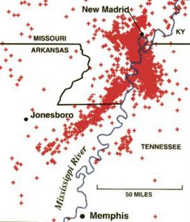 Now this wonderful seismic zone should have the typical looks on the plate of a rift valley feature where the crust is being moved apart. One of the top things I learned in geology class is that on a sphere the hard crustal surface usually breaks in three isometric directions from a center, with each limb 120 degrees offset from the other two. What then typically happens is two of the three directions becomes dominant and then the end point of each of those limbs may serve as another fracture area, using the two of three rule. And that is precisely what we see in the case of New Madrid: a common center with two major sources of quakes and one not so well defined one. The 120 degree offset is a 'perfect rule of thumb' and general only, the offsets can actually be quite set apart from each other and we see this on the shadow section of less frequent quakes that seems to be pointing from the center right at Memphis, TN.
This is, needless to say, worrying to the geologists of Tennessee. The idea of a mangitude 8 earthquake hitting within 50 miles or so of Memphis is one to give a person pause, and since its energy transmission will be quite good it will only be down into the high 7 range at Memphis. Not to speak of St. Louis which can be expected to take a major hit from any seismic disturbance of this magnitude. The folks in Arkansas have done a nice job of showing just how far the last set of quakes went, so we can do a risk assessment. And so has Missouri. And FEMA has put together a comprehensive look via a huge power point download and I will use their numbers... take them with a large grain of salt.
So here it goes for the Memphis, TN area... Over 5 states covering 23,000 sq. mi, 1.9 Million People in 700,000 households with 741,000 people in the expected vicinity of an epicenter, 20 Large Hospitals, 31 Medium Hospital, 10 Small Hospitals, 28 Emergency Operations Centers, 214 firestations, 200 police stations, 7,800 miles of highways, 250 Major bridges, 490 Continuous bridges, 3,660 simply supported bridges, 93 airports, 9 heliports, 76 Potable Water Facilities, 4 Waste Treatment Plants, 5 Major Power Plants, 5,900 miles of water piping,.
Approximately 15% of Bridges Operational, 11,667 Displaced households, 549 operational schools available, 320,000 Households without water, 469,000 Housholds without electricity, 107,000 structures out of 625,000 total are moderately to extensively damaged, 25,000 structures extensively to completely damaged. Debris Generated: 2.5 Million tons of brick and wood, 2.2 Million tons of steel/concrete. Over 1,000 HAZMAT sites to feel moderate to violent shaking with 248 in that last category, 953 Dams with 100 to feel light to violent shaking.
This does *not* address the fact that St. Louis, alone, may feel a magnitude 6 earthquake from each of these events. Further, if this zone plays out like it did last time, a one-time quake is not in the cards and two or three may be a more reasonable number especially with a high number of aftershocks. Nor does it address the critical infrastructure of natural gas, oil, gasoline and other piplines that run through this area. The severing of those *alone* could cripple the North Eastern US as that is the direction the majority of them go.
And we must also remember that these quakes have sudden fissure appearances in the ground, sand volcanos, gas emissions, and sudden thrust/subsidence of large areas. What happens to the Mississippi crossing bridges when the river itself backs up and flows backwards through this region as it did the last time quakes went through here? The railroad lines were also not addressed, and a number of them go through this area including the St. Louis railyards. Also the Mississippi River itself shifted channels and changed its configuration to inundate towns that had been on the river banks. New Madrid was put under water, if memory serves. Addressing *just* the quake does not take these other considerations into hand to be examined.
Of particular worry is that seismic releases may occur anywhere along the rift fault and so could hit much closer to either Memphis or St. Louis or *both*. Not only are the fire hazards going to be high, but the potential of a dam breakage or multiple ones due to changes in subsurface conditions must be considered per dam. Earthen dams ride out other quakes quite well as lateral motion does not impinge upon them much. But land subsidence, fissuring, sand volcanos and gas emissions all threaten these huge mounds of compacted dirt by making them less compacted and shifting their internal structure. The sudden loss of earth to a 2m wide fissure that is 10-20m deep is considerable to such a structure and may promote liquefaction of the dam itself if the fissure runs into the reservoir.
The last time this happened loss of water flow in the Mississippi was noted as one would expect with sudden changes in its direction along with sudden flooding of land that has subsided. This time there will be debris entrained in that fluid flow and it will impinge upon downstream structures depending upon the rate and rapidity of that flow. Add one or more dams to this and sudden overland flooding and surges of water with debris becomes a certainty. And I am sure the USACE has studied the problem, but what *exactly* does happen to the various flood and river control systems when these things happen? Is this entire system survivable? Does this sudden degradation and multiple seismic events change any of the fluid and soil dynamics around these structures?
From this we now know why FEMA is unprepared: they look at limited scenarios not based on past history. In this case the past few thousand years, but that is what it takes to properly determine the possible scope of this problem. No one has even asked what happens to Chicago if one or more high magnitude 4 to low magnitude 5 earthquakes rumble through *that* metropolitan area. They are in the light zone for these events and the region has built up tremendously since 1812. And that is the problem with the New Madrid Seismic Zone. It covers so much territory that everything within its bounds needs to be looked at to see if there is any possibility of mitigating damage even to places not even *close* to the epicenter.
California has been doing its best to deal with these things, so although they have more population at risk they have put in necessary structural codes and at least have real plans to try and meet up with their future. The folks in Cascadia do *not* nor does the mid-west of the US, and when seismic events that are truly large either in magnitude or scope or time or all three happen, there is no preparation beyond what some individual companies and State Agencies have done. While the total population at risk is a bit smaller, the infrastructure and disaster mitigation plans make the possibilities for death, spread of disease and collapse of infrastructure to sustain the Nation more likely. I cannot even put a speculation on the death toll because of this, nor the cost in infrastructure damage, except to say that the FEMA estimate of $14-27 Billion dollars is most likely off by two orders of magnitude on the low side. For a single quake, yes... for the seismic event seen in 1811-12? Far, far off.
Number 2: La Palma landslide and tsunami
Beautiful La Palma island, one of the Canary Islands! Beautiful landscape with the blue of the Atlantic... green of the plant life.... and black of volcanic rock. La Palma has two volcanic peaks: the inactive Caldera de Taburiente and the active Cumbre Vieja along with the ridge between them the Cumbre Nueva. It really does look like a wonderful place to visit. And if you ever do, may I suggest staying on the EAST side of the Island?
Why is that?
Well, a bit of geophysics here, but perfectly understandable. Most geology is pretty easy once you understand the basics.
The old volcano has been eroding pleasantly for thousands of years and the underlying magma chamber causing the hot spot shifted somewhat to the Cumbre Vieja. Merrily over the centuries this volcano built up the island and uplifted it somewhat. In doing that a ridge line formed between the old and new volcanos and many vents started to appear there. As one would expect for a small island in the middle of an ocean, there is much water seeping through everything in La Palma below ground level and often at ground level. All of this is fine and dandy, save that the 1949 eruption of the Cumbre Vieja started to shift the entire mass of the sothwestward section of the island starting from the south and radiating out from the ridgeline to the west or westnorthwest near the old caldera. The rock and soil around the caldera appear to be more compacted and less likely to shift with the other mass, but friction and water filtration there may play a role in the resultant landslide and moving, viscous liquids at high rates of speed to tend to entrain loose material along their contact zones.
As we have seen in New Madrid, saturated sand and soil can liquify given a severe shake and then move as liquid moves and often quickly. Such appears to be the case with this large mass on the western side of La Palma which started to shift downwards during the 1949 volcanic eruption. Looking at other volcanic islands across the globe has revealed evidence of many such slumps by charting out surface material that flowed, as a mass, outwards from the island involved. This is demonstrated multiple times across the Hawaii Islands, especially the more westward and older islands of the chain. But nearly every volcanic island that has a high peak can suffer this sort of slump.
Whenever you take material and start dumping it together it will form a pile. Take buckets of sand and you will be able to build up a sand pile. But as you do that, you will notice that at a certain steepness the new sand put onto the pile will slide downwards. There is an angle at which particle to particle contact can support such a pile and an angle of steepness beyond which it is unstable. This is called The Angle of Repose. From silt to building the Pyramids, every solid has an angle of repose based on grain size, grain shape and contact area and, once you go beyond that angle, the entire structure is either unstable or meta-stable, meaning that it looks stable but a slight change can suddenly alter the system.
So, take dry sand and pile it up and you get one angle of repose. Stick a small hose into the pile and slowly let water seep into the pile. You get a wet pile of sand that still *looks* stable. Give the wet pile a sudden jolt, however, and it will shift downwards, suddenly to reach its new angle of repose and possibly take material and go below that. This is what is happening at La Palma. Hot volcanic rock has one angle of repose. Cool it and water log it and it has a much lower angle of repose. The vents on the ridgeline generally point so that the western side of the island gets differentially more energy than the eastern side during an eruption and off-gassing. The result can be a landslide. Or in this case about 1/3 or so of the island suddenly rushing downhill to the see as a viscous and heavy liquid. It is trying to shift its angle of repose, but has nothing firm to land on and so heads out to sea as a single mass.
That mass of this area is in the ball park of 1 trillion tons (US).
This causes a tsunami. Actually, by all modeling in scale with proper material equivalencies and via computer this causes a megatsunami. One benefit of being at such a distance from the eastern coast of the US is that the initial energy in wave height spreads out across the entire wave front. The wavelength, the distance from normal sea level past wave and trough back to sea level, does not diminish. So the wavelength by estimations of the amount of material in the flow will cause a wavelength of 20-30 km (12-19 miles), so the water onrush will be that distance and push to move the wave height forward. Initial wave height has been estimated at 540m (1,770 feet). Now to calculate the initial wave front at its origin we can look to the proposed slump area here and I will use the ballpark estimate of 40 km (~25 miles).
Now to move to the US side of things starting at Cape Cod and moving to Miami which I will use somewhat older but more readily available numbers here as a rough order of magnitude estimate. Leaving out Maine, New Hampshire and, say 40 miles of Massachussettes and do a bit of rounding to make it a nice even 1,800 miles (~2,900 km). So each initial unit of length will spread out to cover 72 units or so of final arrival coastline (yes, a few things are being left out here and some coastline is further out than others, but this is back-of-the-envelope sorts of things.... if you want exactness, talk to The Shell Answer Man). So the incoming tsunami is 7.5 meters (25 feet) high and then pushed 40km (25 miles) by its wavelength. As seen in the Indian Ocean tsunami, as the wave form gets to shallower water the initial wave height builds as the faster parts of the wave form catch up with it. That tsunami had a wave lenght of about 1.2 km and it pushed up to 5 km inland at some points and less at others due to coastline variations. In comparison this wave will not stop at simple uphill gradients and continue to build up as more of the wave form arrives. Over flat terrain it will just push continuously inland for 20 minutes to an hour due to its long wave length and the fact the trough is half of it. In areas with upslope gradients the water will get higher and higher until the trough portion of the form starts to move in and the ocean flow in behind it to mean sea level. Take 7.5 m as the highest part of the wave and cut that in half for average height over the surge part of the wave form, lessen the speed for hitting the coast but build the height as more water piles up, say at a 6 original km to 1 final km wavelength..... call that 2.5m per minute? Damn fast, no matter how you cut it. On the scale of the Indian Ocean tsunami this would be in the centimeters per minute range due to its short wave length, so barely noticeable after the initial piling up.
Some breakup will happen due to intervening islands in the Atlantic, the fractal geometry of coastline and some other factors on the continental shelf I haven't considered as this starts out as a mid-ocean tsunami and will begin to slow and rise well before it gets to the coastline due to the continental shelf. But the release of energy, wave form and distance are the major factors here. This wave will conform, somewhat, to topography and seek the lowest and shortest distances with the least slope to head into, but hitting islands it will just build and build. All the coastal islands from Virginia to Florida will simply be overtopped and much of their mass entrained with the wave to form a roiling debris flow and then standard tsunami push inland. Long island will be inundated and its southern portion churned by the waveform but it should not diappear completely once the largest wave subsides, but the massive debris flow will still continue onwards at a reduced height past it.
Cities with flat terrain not much elevated from mean sea level or on direct bays or estuaries will be at high risk from Cape Cod to the Florida Keys.
The warning time will be 3 hours or so, and the waveform will be tracked by aircraft flying over this wave and by ships at sea. Expect some ships to be negatively impacted by this wave form, especially those by undersea mounts and other undersea features.
There are lots of *ifs* in this one, but a worst case scenario is devestating. If the initial landslide peels off into faster and slower sections, then high numbers of *multiple* though lesser tsunami waves will impact repeatedly. The one thing that can be said is that this sort of landslide is not a slow motion one: the land stays put until it is in motion and when it moves, it moves quickly.
Number 1: The Yellowstone Caldera Complex
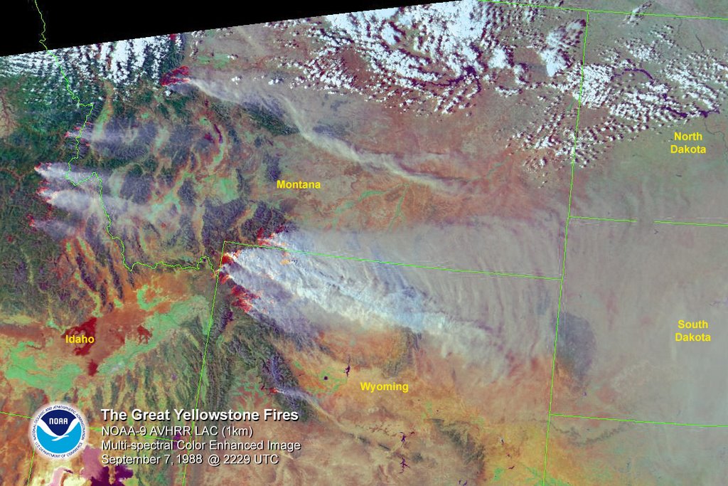 Yellowstone National Park, Wyoming and parts of Idaho and Montana. Some of the most majestic and scenic landscape on the planet and a geologists dreams with its mountains, hot springs, geysers, fumerols and all sorts of other oddities. Many parts are still pure wilderness and have rarely been seen by mankind. A tourist attraction for its natural wonders from the hot springs and boiling river all the way to its geysers. Geologists were kept wondering at it since its discovery and had many strange anomalies showing up: volcanic ash that could be traced from the mid-continent all the way back towards Yellowstone at multiple layers, slow uplift of the region, tectonic activity including minor earthquakes. Something was happening there but no one knew exactly what it was... until aerial photography allowed the entire park to be surveyed and compiled into a mosaic. A geologist looked at that and said that looks like a volcanic caldera... and then realized the scale of it. This is the Yellowstone Caldera and the Island Park Caldera to the south of it. Since then the folks at the USGS have done a fine, fine job of piecing it together since the entire system started 17 million years ago.
The core to the mantle of the Earth have many ways to relieve themselves of excess thermal energy. General convection works for the most part of it, but hot spots of material arise, possibly from all the way to the core, sending a slow and steady jet of heat upwards that is little deflected by the slower convection cycle. Once this hot spot gets to the crust it forms a volcano using the underlying plate material as its basis with some add-ins from its journey. And if the plate it erupts through is moving, then it will shift from spot to spot and form new volcanoes over time. Hawaii is a prime example of that as it and the sea floor mounts that had once been active volcanoes stretch from the head of the chain all the way back to Midway Island. This process started 17 million years ago as a hot spot came through the North American plate and erupted. As the plate moves over the hot spot new volcanoes form and erupt. Continental plates being thicker will tend to slow this process down, but a very active hot spot can still be a good sized volcano chain in its own right. But if the hot spot is slowed sufficiently it will start to build sub-surface magma domes and spread laterally slowly thinning out the crust over it while slowly thrusting it upwards. At some point this structure becomes metastable and a sudden venting of gas or inrush of groundwater due to fractures will let the entire crust fail catastrophically over that magma dome and the volcano erupts.
That is Yellowstone. Its crater from its last eruption was 40 miles in diameter, give or take a bit. And that was its latest eruption with an eruption cycle of: 640,000 years ago, 1.3 million years ago (MYA), 2 MYA, 4.3-6.5 MYA, 7-10 MYA, 8.6-10.5 MYA, 10.5-12 MYA, 13-15 MYA and 15-16.5 MYA. There are differences in agreement on numbers and spacing, but the eruptions did happen via ash deposition in the stratigraphic layers so that is known. Actual position and number of caldera's active is not well understood for the far past, but for the more recent past the cycle appears to be consistent. As with the examination of the sand blow events in the New Madrid area, this pattern shows one of decreasing cycle time over time, which fits well with the understanding of the process of melt fluid having problems getting through the plate initially, but then being able to make more direct upwards paths as the plat shifts over it by using older paths so soften crustal material and change course upwards.
So let us take a look at some Earth history starting a bit back and working forward:
15-16.5 MYA there was a significant oceanic fossil change in the oceans and this fits well into the Miocene epoch and its subdivisions between the Burdigalian and the Langhian. The fossil record is charted by cross-comparison of fossil types and species and abundance so that a more accurate record of what lived when can be cataloged and charted. This work has been going on since the mid-19th Century and continues to this day with the examination of single celled organic fossils now possible in well preserved and undeformed strata. Once a range of time lines for species is done and their beginnings and endings put together en-mass, then an idea of how life evolved over time is formed. If a large number of species end within a very close time range, this becomes known as an 'extinction'. These Miocene changeovers in fossil species are minor extinction events that happened at least for those life forms examined and possibly others.
13-15 MYA has a rough correlation with the Langhian-Serravallian changeover, although it is not a great fit, to be admitted.
5-12 MYA has a good correlation with the Serravallian-Tortonian changeover.
8.6-10.5 MYA falls within the Tortonian and appears to have had no impact on the large scale species line-up for the planet.
7-10 MYA has a good correlation with the Tortonian-Messinian changeover.
4.3-6.5 MYA falls well within the bounds for the Miocene-Pliocene extinction event.
2-2.2 MYA falls at the end of the Gelasian within the Pliocene and gives a good accordance with the Pliocene-Pleistocene extinction event which also marks the beginning of the Quaternary period.
1.2-1.3 MYA falls within the Early Pleistocene and does not appear to be a planetary wide extinction event.
630,000-640,000 YA falls after the magnetic pole reversal marking the Eemian interglacial period, and is a poor correlation with a major extinction event on a planetary scale.
Now, just because an eruption does not cause a mass extinction on a global scale, does not mean that it has no localized impacts. If one looks at the Snake River Plain a clear imprint can be seen of past caldera events is obvious. One of the great topographic signatures of intracontinental megavolcanoes that have been around for awhile is that they leave a tell-tale trace as the continental plate moves. In the case of Yellowstone it is this broad, flat expanse leading out into Idaho for the Snake River to wander through. That is where the Yellowstone hot spot WAS in the past. And that is what it DOES to the landscape.
Now lets go in reverse order and see what the effects were of some of these eruptions, locally. And thanks to USGS for some of this info!
630,000-640,000 YA released 1,000 cubic kilometers of ash, rock, dust and debris along with multiple pyroclastic flows of super hot material traveling at high speeds, locally, which formed the Lava Creek Tuff. Mt. St. Helens, which we all have a good feel for, put out about 2 cubic kilometers of similar material. On rough estimate that previous eruption of the Yellowstone Caldera was 450 times that of the Mt. St. Helens eruption. It formed a caldera 30 km x 70 km (18 miles x 43 miles) within which the modern park is found and welded its ash via pyroclastic flow into the , which can be seen in and around the surrounding landscape. However, this is still smaller than Mt. Tambora which released 100 cubic kilometers of rock and ash, but that was luckily situated in an ocean where most of it could fall back into it and only harm localized sea life. Further, the Mount Tambora eruption, though it did have great force, was a phreatic eruption that took out the entire volcano. Thus the effects of having a 'Year without a summer' as in 1816, would most likely be repeated if not actually worse due to the directivity of the ash eruption and the sheer mass of it. Some will go out in pyroclastic flows, to inundate the immediate vicinity out for many miles, but it does not have water to superheat and forward its progress so a flow like seen from Krakatoa is not expected. And, by-the-by, the smaller Krakatoa eruption in 1883 is usually seen as the closing act of the Little Ice Age. So one does expect Global Warming coming out of that cooling period starting in Medieval times. This last ice age was thought to have been started by the eruption of Mount Toba 75,000 YA which had an ash profile similar to that of Yellowstone. Note that Toba also plays into all of this as do all of these caldera makers.
1.5 MYA last constrained date for the Glenns Ferry Formation in the Hagerman Fossil Bed National Monument, Idaho.
2 MYA sees the formation of the Huckleberry Ridge Tuff which was formed by an ash cloud in the neighborhood of 2,500 cubic kilometers. This was a widely dispersed ash fall across the continent.
3 MYA is the formation of the 280 cubic kilometer Mesa Falls Tuff layer.
5 MYA approximate start time of the Glenns Ferry Formation.
12 MYA sees the formation of the ashfall fossil beds which have a good representation in the Ashfall Fossil Beds State Park in Nebraska. This event is traced to the Snake River plains area and is called the Bruneau-Jarbridge volcano so as to differentiate it from the modern Yellowstone volcano.
17 MYA sees the Hagerman Fossil beds start to be laid down along with basaltic lava flows that covered a wide geographic region that are likely associated with the early caldera making process. Repeated events of lava and ash flows create stratigraphic beds of same that can be researched so as to define the mineralogy and paleontology of each of them so as to use it as a typified stamp for those events. Evidence for this series of eruptive events can be seen at the Kidd Creek Mine in Timmins, Ontario via its stratigraphy. Note that rhyolitic flows and ash events are seen this far away, in some depth and detail although the mine itself is going after deeper deposits and this is just one of the many overburden layers. This would by typical of a startup large caldera going through its most cataclysmic eruptions so as to form itself and get rid of the overburden in the area, which looking at surrounding remaining terrain north and south of the river valley, is pretty rugged.
The conclusion about the Yellowstone Caldera Hydrothermal System?
Bad.
Note that what are given here are HIGHLIGHTS of the worst that this system does. In the past it has seen multiple eruptions of lava flows and other volcanic typical events: earthquakes, pyroclastic flows, debris flows, lahars, subsidence, surface deformation, landslides, and all the fun geothermal vents and geysers we see today. So this system has many different volcanic modes of operation, the worst of which is the caldera event partially emptying the subsurface magma chamber.
150,000 YA the entire Yellowstone Lake and caldera region started to see uplift along with a minor caldera event in the western thumb of the main lake. This deformation continues steadily to this day and has seen shifts in lake levels over the human time scale. In the 1920's docks on the northern portion of the main lake were made and today they are as much as 1 meter above lake level and many pilings now sit on dry land. In 1959 a magnitude 7.5 earthquake rumbled through the zone and was most likely caused by expansion of the magma chamber with the inflow of new material. Current seismic and mapping projects are being set up to help create a subsurface model of the Yellowstone complex to better understand what is happening there. What *can* be said about past eruptions is that they have left meter high deposits out to the Gulf of Mexico and about a foot high out to the eastern portion of the US. Typically a large eruption event coincides with a period of global cooling if not a large scale extinction event. And this complex is now in its prime cycle for a major caldera eruption, after which multiple smaller eruptions and lava flows can be expected as the magma chamber empties as material expands once the overburden pressure is relieved.
Short of an 8 km in diameter asteroid impacting the Earth, Yellowstone and its brethren caldera makers on the large scale are the greatest threat to humanity on this planet. And technology is not there yet and our understanding of the forces involved will not come easily nor quickly. For every person who I read about wanting to get Lasers to 'lance volcanoes' I must shake my head and ask why they wish to do something that will have absolutely unknown consequences? Until we can fully understand the forces, pressures, and directivity of magma currents and interact those in some reasonable fashion with local geology, trying to relieve pressure *now* may start a series of smaller and harder to control events that will have consequences as bad if not worse than a single large event. An asteroid broken into chunks becomes a distributed dust fall that will take decades longer to filter out of the atmosphere instead of the dust thrown up by an impact from the denser lower atmosphere. Similarly starting a chain of smaller volcanic eruptions may cause a faster cycle of smaller eruptions that will entrain dust on a continuous cycle into the atmosphere and generate a global cooling cycle *worse* than a single large event.
The answer for survival is to get off this damn planet.
Earth is a fine *starter home* but the problems with it are beyond repairing.
It is hostile to life, for all the fact it harbors life.
99.9% of all species that ever lived are extinct.
Environmentalists should *want* us to move industry to the vacuum of space where terrestrial pollution will not occur.
Unlimited energy is available from the Sun until we need to get further away from it to explore.
I want the meek to inherit the Earth.
So the planet can kill them.


 Supporting Friends and Allies


3 comments:
Have you considered anti-depressant, anti-psychotic drugs? They say they sometimes help.
visit my blog.....and be nice.
http://petesplace-peter.blogspot.com/
Peter - My thanks! The problems I suffer from, beyond the diabetes, hypertension, and hyperlipidemia are due to the effects of a medication on my brain structure as a side-effect that is coming to light as a problem from that medication. My family history has a pre-disposition to narcolepsy/catalepsy on one side of my family but was triggered off by the structural changes... obviously there was something that prevented them from happening, most likely in the mechanism that regulates the sleeping cycle.
Currently I am on an anti-narcoleptic drug at its maximum dose, but that needs distribution throughout the day and has a concaminant cyclicity to it within my system. The sleeping, attention, energy, concentration and other cycles have been shorn from normal diurnal rhythms. That said the general overall energy levels are somewhat higher, but my ability to recover physically from exertion is still impaired. I have tried one very mild anti-depressant which can sometimes be beneficial, but it had the side-effect of making my actual conditions *worse* while raising my mood which was something I found to be non-acceptable both in outlook and experience.
When nanotech gets to actual, physical repair of damaged brain structure, I may have a look at that. As it is I use high amounts of mental activity to get some semblance of working mental capability to return so I can *understand* what is going on around me. That is working, but the connective gulfs between how I *used* to think and how I *now* think remain. From a purely internal view I judge my overall mental capacity at sub-60% from three years ago when this started. This is a stark improvement from the 30% or lower range from when I started blogging. My body, stubbornly, still gets exhausted from a simple day out shopping and incapacity in physical energy remains: my stamina is shot along with recovery ability for it. But that is what happens when a medication interferes with the systemic chemistry the body uses to promote recover at a cellular level... do that for a few months and larger problems start to manifest.
If this piece seems *depressing*, to me it isn't. This is the cyclic nature of the planet we live on at work, and its history reminds us of that via geology and common human experience when episodes come close enough together to let previous generations record same. This is that 'reality' that folks talk so much about and how I deal with it: understand it, comprehend it, learn what it is and *why*. Ensure that you have accounted for all major variables, which in these cases are relatively easy to do. Once global thermonuclear war passed out of the top 5 for civilization survival with the fall of the USSR, these remaining threats all moved up one notch. As mankind has boundless stupidity, we can probably get something just as disasterous to civilization and hike it into the top 5. #1 is a threat to the bio-ecosystem of planet Earth. Anyone who thinks that 'laser lancing' is a solution I have a mental construct: take a soda can, heat it to past the boiling point of the contained liquid, shake well for a few minutes at that temperature... then try to poke a pinhole in it and tell me what the expected results are. That is what trying to deal with a volcano the size of Yellowstone or the other megacalderas is like if we do not spend a good few decades understanding the underlying geophysics.
For #2: We will find an answer for that on the exact same day as we find an answer for subsidence in NOLA. Since we do not want to address either topic, there is no remedy for it. Massive tsunami on the East Coast is not my idea of a good and fun time on this Continent.
For #3: We could build a fail-safe set of pipelines, railroads and such to go around the northern extent to this seismic area in the Mississippi basin. That will take decades to build along with getting rid of *all* the unreinforced masonry buildings in that zone. That is decades to do and it has not even been addressed.
For #4: Sorry, there is no solution for it. Move population up and out of the coastline above all previous inundation areas and hope for the best. Suggest moving parts of Portland, OR and other cities in the danger zone inland by a few miles. Also develop a program towards seeing if there is any sort of structure made by man that can withstand a 5 minute mag. 9 earthquake so as to keep all occupants safe and house more than a few people.
For #5: California is doing all it can and I wish them well. The 'Big One' will not be fun. I suggest that anyone not wishing to experience it not move to the area from LA to SF, and head inland about 50 miles away from the immediate fault zone, minding to stay away from lesser fault zones.
Is that depressing? Not to me. It is a realistic assessment of the threats and what is being done and what can be done about them. For #1: get off of planet Earth, we will not survive if we stay here and only here. That is a joyous look to a future of mankind no longer bound by planetary life, not a view of gloom and doom... save for those that are stuck here when it happens. I just assess the threat, tag it, deal with it, incorporate it and move on and do not obsess over it.
I find it strange that others cannot do this.
Post a Comment