Part of my views on many things in general happenings requires that events not be taken as 'incidents' but that they get some contextual analysis based on available data, historical background and a look at multiple other players in any human or non-human based happening. Things like the tidal wave in the Indian Ocean in 2004 have the causation at crustal plate boundaries which have steadily applied motion pressure, but that may not actually move due to friction. Once the amount of energy that is necessary to overcome the friction happens, then an entire segment of fault can suddenly slip and change position and be upthrust. That changes the water column and a tsunami results.
In the area of human affairs, the idea is that not only is no incident unconnected, but that actual events must take place at some place and at some time. This gives such events geographic and spatial boundaries. So, when Baron Bodissey at Gates of Vienna started looking at the Jamaat ul-Fuqra Islamic group in Georgia (US) the first thing I didn't do was read the commentary and analysis. No, I started by downloading the pictures and getting Google Earth up and running so that I could then have context fro the entire area and then the group's placement in it. Yes, endlessly exciting, isn't it?
I go over the basics of Google Earth with this introductory post on GIS and INTEL Analysis, so one can get their feet wet. Then a bit on how you, too, can become your very own All Source Exploitation organization. After that a bit of a demonstration on how to use multiple sources and the ability of Google Earth to give you a 3D environment to find things that folks really want to keep hidden, which in this case was Syria. Basic geologic and industrial site analysis in Syria is done with this post, to show how understanding geology, economics, transport and trade will lead to giving a firmer basis for understanding how a National program works. Then a WMD round-up for Syria with the places that can be found and why they matter, is done here.
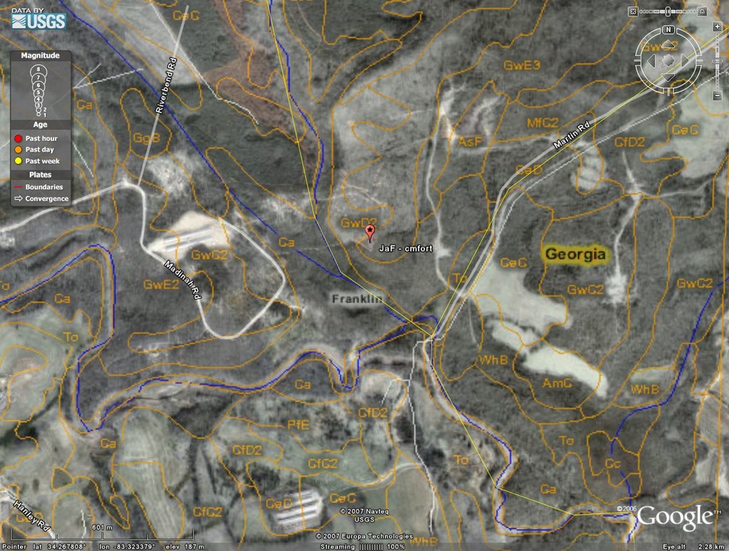
The hunt starts with a map. You can't find the territory unless it has been described someplace and has a generalized position involved. And generalized is exactly what I got:
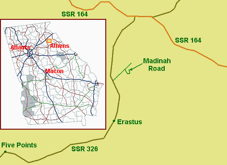
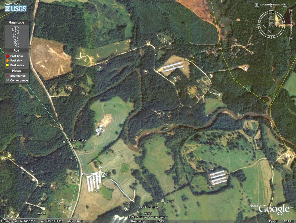
Just what one needs to start their day! From there I did a quick look up in Google Earth, found the neighborhood in the vicinity of Erastus, GA and just did some simple feature matching to get oriented. That doesn't take too long at all:

Not too bad, really. You can see Erastus in the lower left, and the road snaking up and the only viable side-road coming from it. And now a bit closer:
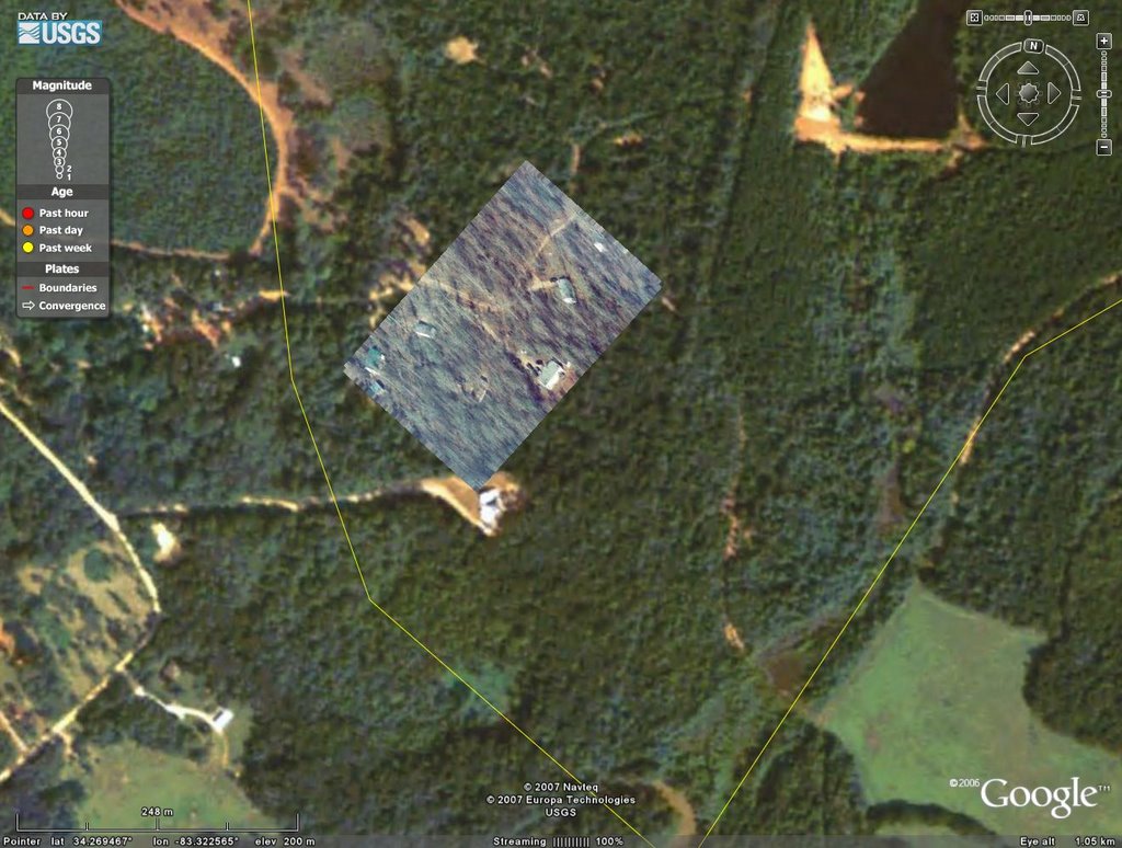
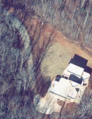
With the area now scoped out, I used the downloaded image of a number of buildings in amongst trees and went to work on finding and placing that. I will do a complete set of steps and then leave out the drudgery ones for other places. First up is the image to be placed. Remember that this is taken from aerial surveillance and is uncorrected for geometric, angular and geomorphic distortion. Taking such a shot at an angle changes perspective, puts distance distortion due to the curvature of the Earth and local geographic and geomorphic displacement into it and that perspective angle will only give a partial view of things. Some things can be corrected for, others not, and even the underlying GE imagery has some of this, although much has been corrected for. That said, the first image:

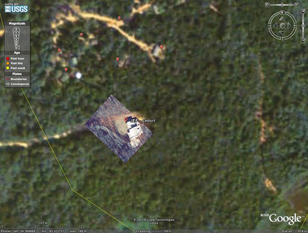
Then the rough placement by eye as an overlay in GE:
Perhaps not a thing of beauty, but it works! Throw in some placemarks to point out where building should be and things like road intersections, trying to ensure that they will not be too obscured:
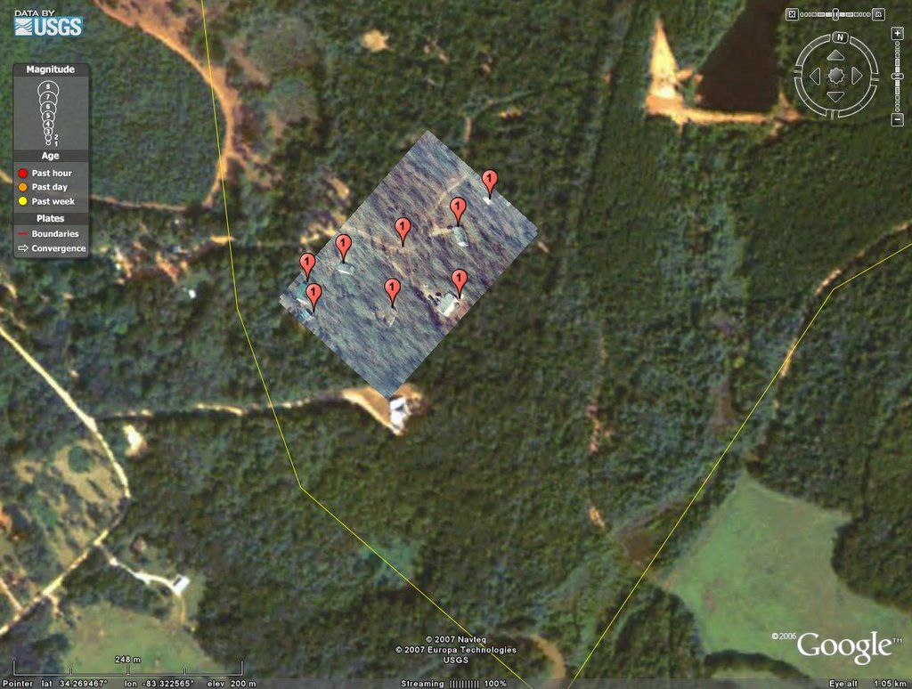
Then move the opacity of the layer down to see the underlying imagery show through so one can make an inspection of the placement.
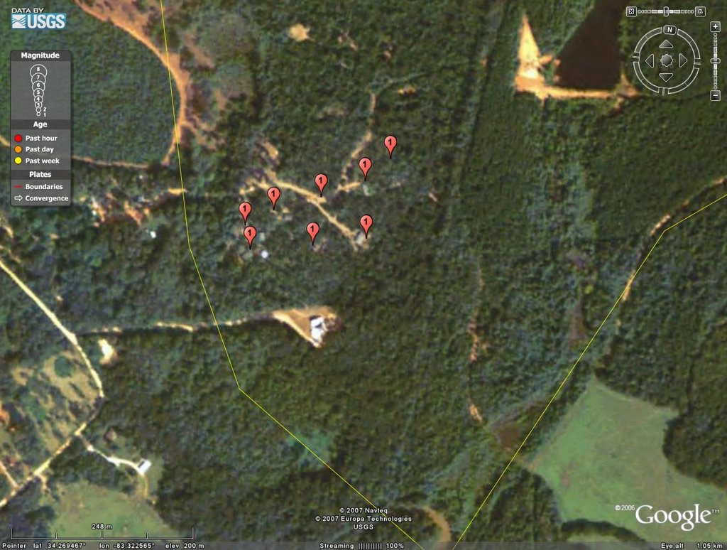
Seven out of eight isn't bad, particularly as the GE imagery was taken in a period of full growth on the trees, while the Gates of Vienna camera work was done during winter. That said the imagery in GE is awful. Doing work with it for this site, as compared to the Syrian sites, by and large, will be a job of 'blobography' or trying to figure out what minor textural and tonal variations mean in a blob. Add in JPEG or other compression schema artifacts to the GE imagery and one then keeps the bottle of aspirin handy. But the confidence level for this placement is in the 95%+ range and near enough to dead certainty because of the road intersection and building placement to ensure that there is nothing else even remotely nearby exactly like this.
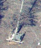
The next series for a farm house and out building are less than stellar, however:
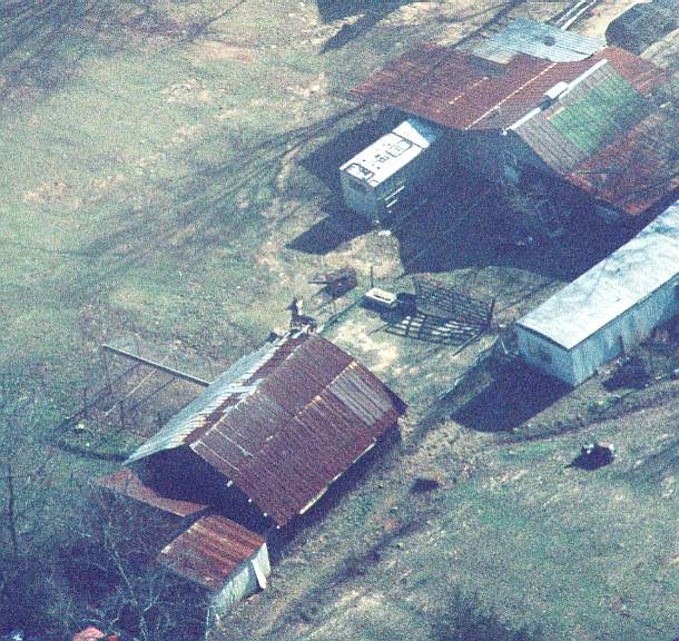
Such a lovely and detailed image! And now I need to place it in the blob field, which was not a fun piece of work:
And then turning the layer off and examining the reference points:
Better than trying to find al-Bayda in Syria, that is for sure, since that had zero reference images. The points of correspondence are good, but not highly convincing, to my eye. I would put the certainty at about 30% or so as there are a couple of other places that might be just as good a fit in the vicinity. Two aspirin later I am ready to hit the 'fortress' as the good Baron labels it, and thats good enough for now as a designation.
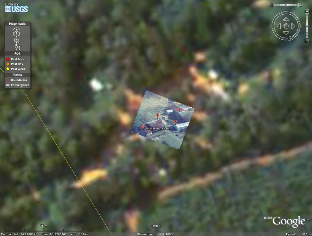
Image:

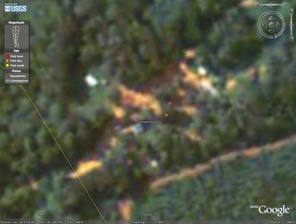
Here there is no question due to the configuration of the building, the cleared area, the road and all surroundings. This is a 100% placement match. Thus a placemark overview of the area can now be had:

I did a quick analysis of the mystery objects as seen, also, leaving out the first as that was ID'd as optical illusion and ground clutter with a farm vehicle involved. Thus each on its own:

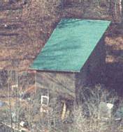

Pre-fab tool shed. Note it is open air at the top, so nothing of high value or something that requires air circulation, like chemicals and such. Shed is 95% certainty, function unknown.
This, BTW, is why INTEL analysis is never certain on things. The only way to get a trustworthy report is from on the ground HUMINT that is, itself trustworthy, has good knowledge of what it is looking at and has good local knowledge. If any of those are lacking, then the value of such reporting degrades. It is best to synthesize analysis across multiple realms of INTEL so as to combine HUMINT (Human INT), IMINT (Imagery INT), and other forms of INT like SIGINT (Signals INT) and some of the non-obvious like MASINT (Measurement and Signature INT). Very few INTEL Reports will ever come *without* a degree of certainty attached to them, and that degree is based upon human judgment in weighing and weighting each factor involved. Doing that requires knowledge of the background of each of the source reports and the dependability and reliability of those compiling the reports. Making the cross-INT study then puts all of the various individual reports together to see what parts are cross-confirming, which are at odds and then look at all the odd factors picked up by only one or two reports out of many. It is often those human insight based 'odd man out' factors that can lead to fruitful synthesis of what is going on and give a better and broader understanding of how all the reports fit together and *why* they fit the way they do.
There is, literally, no science to this. There is human skill, reasonableness, and then levels of certainty attached to such reporting. At the highest levels of Nation to Nation sharing, each Nation brings its own strengths and weaknesses on a given subject and the utility of cross-comparing reports the allows for a deeper understanding of subjects to be done. As an example the US had no HUMINT in Saddam's Iraq, but I can almost guarantee you that Russia and France *did* because of their ongoing trade relationships with Iraq. The reliability and dependability of those individuals may be in question, but when multiple individuals without knowledge of each other report similar things to different Nations and they compare notes, then you start to form a better understanding of what is going on.
From here I had a long discussion with the Baron on the feasibility of that central 'fortress' building to be a hold-out place due to the nature of the roof areas with overlooks.
 Overview Overview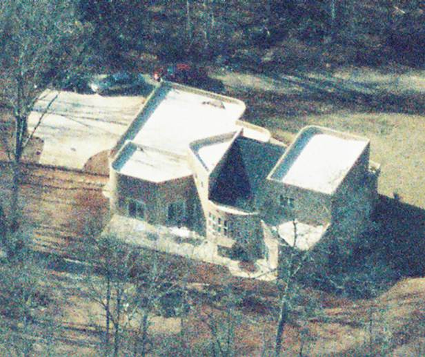 Image 1 Image 1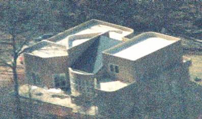 Image 2 Image 2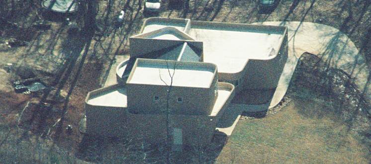 Image 3 Image 3 Image Tower Image Tower |  Image 4 Image 4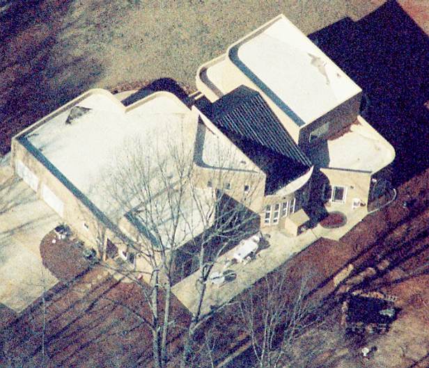 Image 5 Image 5 Image Cars Image Cars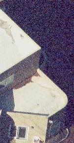 Image Bevels Image Bevels |
As a hold-out position I don't think much of the place, really. First off, although it has a good Line of Sight (LoS) from the top position outwards over the gravel area and main driveway in, the trees and scrub encroach upon two sides of the building and notably the garage area, which is not the place I would like to have someone move to when trying to defend a building. In point of fact I would like my garage to be situated on the other side of the building, thus making anyone coming into it have to go the long way around while under observation.
Further I would dearly love to clear out the trees and scrub completely around the building itself as there are far too many ways to get to it without a clear observation and LoS. If you pop back up to the GE view, there is plenty of tree-space to allow for this and still retain much in the way of trees around the building. If I wanted to really hinder incoming and uninvited guests, I would then place saplings or thin trees with high canopy in that area or prune such trees so as to open up the floor area while retaining canopy cover. This is something well known to the South American drug gangs and such organizations as FARC and Shining Path. To a small degree this is done, but the high canopy is not being pruned at the lowest levels and then encouraged to fan out. Now as this is hurricane and nasty storm prone territory there is a reason for that, too, as interlocking mid-tier canopy not only breaks up incoming wind gusts but also makes the forest more stable and harder to dislodge individual trees. For purely military work, clear out far enough so fallen trees and branches are not a problem, encourage high canopy growth and generally clear out the underbrush. Or put in a small garden with very low hedges: looks great, gives no cover and removes suspicion that you actually *are* clearing out your firing paths.
The building itself has many oddities, some relatively easy to explain and others less so. First off is the non-alignment of the building structure, in whole or in part, to Mecca. I used an online lookup for shortest distance and constant compass directions, which are two widely differing numbers in this part of North America, here, and with a few rotations found nothing that fit with either of them. If you are an Islamic organization, then having a readily and easily identifiable wall arrangement so that one can actually find Mecca is important. Still, I am just doing the quick, thumbnail analysis so I might be off and someone with better background can find that alignment. I haven't.
Looking at the building from all of the angles reveals that the central portion looks like an original building, with more or less standard roof, with the abutting garage and other section on either side of it as somewhat newer construction. I suppose someone might go through all the trouble of putting a corrugated roof on such a place, but it is out of the general tone of the leftward garage area and rightward area, when facing it from the forest direction and on the long roof side as seen in 1, 2, 5.
The actual driveway is planned concrete and only partially done as seen by the section at the garage in which the natural curvature there of the set concrete points to a section that should then go out in front of the house as a parking area, but there is forest there now. Or at least trees. Taking those trees out is a hard days work with a chainsaw and two men. Maybe two days for one man with a chainsaw. "Community of the Impoverished" or just plain lazy?
The over structures on the adjoining parts to the central house, garage and opposite side, are interesting. The Baron wonders if they are sniper positions, especially the triangular area on top of the garage with its roof and windows and such which he refers to as 'Tower' while I refer to it as 'death trap'. The place is well situated to fire into... the forest and scrub trees. Its LoS to the driveway is *blocked* by the 3' high walls around the roof itself. Not what I would call a prime locale for putting snipers, even those that are fool enough to go on the roof of that triangular area. Better situated, but only with balconies, is the more oblong and blocking portion of the opposite side which has one balcony overlook on the open area and to the driveway entrance as it comes out of the forest. But, it is a balcony and fully exposed. And contrary to popular belief, spraying rounds at orbiting helicopters is neither easy nor safe, especially if said helicopters can fire down and onto exposed balconies and roofs. Any half-way capable SWAT team will make mincemeat of such... even worse is they will be firing pepper rounds down onto same and making a noxious, painful cloud for anyone there and you had better make sure you have little in the way of exposed skin or mucous membranes. Hard to fire a weapon when you have pepper powder working on your pores, eyes, nose... very hard to do much of anything and you do *not* get desensitized to that. Ask anyone in the trade of cutting up peppers what happens when some pepper juice gets on same that are *not* used to working with it.
Another problem that the top roof and possible second story structures has is long distance sniper fire. I place the top roof above the triangular and oblong second story pieces about 20' or so above ground level, if not a bit more. The shadow cast by the building at that height is about that of the nearby trees, meaning that observers should be able to just see over the treetops. Now this does point to forethought in that but it also points to the reverse problem as one of the weapons in this post of mine points out: the Barrett .50 Caliber Rifle, accepted by the US Army in 2003 and given the M-107 designation.

This weapon has been battle tested in Afghanistan and Iraq and has confirmed kills at up to 1.5 miles. I can easily find a few places with local vertical exaggeration to be above local building tree-top level and have LoS down and into the relative hollow that this building is in compared to surrounding terrain with a 20' to 50' decline over a distance of 1.2 miles. Two of these are in relatively cleared areas and one in a higher, wooded area nearby and under 1.0 mile away. One thing that folks do have to realize is that there is a difference between local sharpshooting at targets of opportunity and true sniping. Actually, I am coming to deeply respect this single weapon and the distances it can reach out with accuracy, even with just its standard .50 cal, not to speak of its slimmer but longer range version bullet.
As a defensive arrangement, I would be hard pressed to find a place less suitable, particularly as long distance observation and fire can be directed from surrounding countryside and those individuals would be very hard to spot, especially in the pure observers role. On the ground is another matter, however, and this Islamic group appears to be drawn from the US African-American community, by and large. And the good Baron has a second post on them here. And I have not had a chance to do this placement in GE so I will leave off here and do so and see if anything new pops up. If not, then those police organizations that have dealt with entrenched groups are relatively aware of the standard and not so standard measures taken in woodlands and such. I would expect those to be taken unless this community is drawn from urban and not rural surroundings... then you have the problem of no applicable experience unless there is good outside leadership on same. Hard thing to do *and* run a religious community at the same time...
And now for the UPDATE:
I will say that to properly understand and typify what can and cannot be easily done in a place does require actually understanding the topography, geology, soils, rainfall and such, so that one gets a good idea of what is actually going on there. If you can't get to it first hand, then data collection across the board and then analysis is vital. And to do that one *must* get the necessary data and online that can be tricky. So finding the geologic maps of Georgia led me to Chuck and Rachel's page! Actually, directly to their index of geologic maps, but they deserve the plug for the damned hard work of making it available. With that I just downloaded the map I needed, put it into GE and did an overlay. The center JaF marker puts down the reference point for data:

But what does it *mean*? I can hear that being asked by everyone...
What it means is that there is a belt of rock running through that area and into South Carolina and North Carolina that has been heavily metamorphosed. Chuck and Rachel go through that on their thumbnail overview of the three main geological regions of Georgia, of which this is the Blue Ridge/Piedmont area. I read the site location as bg2 which, in the Legend, is Biotite Gneiss/Amphibolite. The Biotite is a form of mica, which is a mineral that crystallizes into a flaky number with lots of sheets of it compressed together. It used to be used for making the glass on fuses for the home power switch box, back in the day. This form of mica has some iron and magnesium in its structure. When in granitic rock you can often find garnets in with mica. This however is gneissic. Thus the biotite is probably bunches of small crystals within the rock itself. Also mixed in are amphibolites, which would be the para-amphibolites here, due to the presence of the biotite. Because of the character of these rock types, they do weather easily in wet climates, which is most of Georgia.
From there comes the soil analysis! You mean you weren't looking forward to this? But it is absolutely, positively critical in answering all the necessary things that people have been asking about what this group can and cannot do in the realm of terrorism. At least *easily*. In any event I went to the US Dept. of Agriculture and then burrowed through their online soil analysis database and finally dug up how to work it and get the necessary information:
A very, very close up map of the area that even distinguishes soil by slope! Such are the wonders of the modern world. Something that back in the 1990's would have taken me weeks to do I now do in minutes. Mind you I still end up sitting just as long in doctor's offices, but some things will just not improve, it appears. Now what we have here is this organization sitting on the crossing of two soil sample boundaries, but they are heavily related. These are GwC2 and GwD2 which, from my notes as I didn't bother to download the database, are: GwC2 - Gwinnett sandy clay loam, 6 to 10 percent slopes, eroded, and, GwD2 - Gwinnett sandy clay loam, 10 to 15 percent slopes, eroded. My first thoughts on the nice hard clay were dead wrong! Nope, instead you have something even *harder* to work with because it is so soft. All those wonderful, weathered minerals have turned into sandy clay particles that have lots of biota attached to them now. That gets you a lovely soil known as loam.
As one may have noted, this site is in a river valley that looks to have a high water table to it, thus making for nice, rich soil, with plenty of water, lots of disaggregated clay minerals and so very, very crumbly... and on a pretty decent slope, too! Now if you are a farmer the slope is cause for concern, but that can be dealt with. If, however, you are trying to dig tunnels and such? Forget it. You are dealing with a high water table, surface run-off and soil that doesn't compact all that well and is well saturated. That lovely reddish look is from the feldspar and other minerals that weather out to that lovely clay and never do form a good hard clay-pack, due to the organic chemicals and stuff that picks up on it. Dig a trench and stick a pipe in it, yes. Dig a tunnel? Wet, sloppy, crumbly walls and ceiling... no thanks! You can, but shoring that up is a task in and of itself.
Thus all of this points to surface work and the one thing that is very and extremely worrying is the location. Georgia is good farming country. Lots of fertilizers. Lots of chemicals. Does anyone remember the diesel/fertilizer enhanced bomb of Oklahoma City? Also of worry is that pesticides serve as great precursors to nerve gas and various other toxins. Luckily these folks haven't taken up farming!
Now for type identification of the group, and this is the hardest. There are two major expansionist Islamic terrorist organizations on the planet: Hezbollah and al Qaeda. Hezbollah is an Iranian/Syrian affair with branches in: Lebanon, Bosnia, Chechnya, Saudi Arabia, Argentina, Brazil and Venezuela. They are the 'direct attack, spare no jihadi' folks and prefer outright offensive action once they have enough weapons. Extremely dangerous as Israel can attest to. al Qaeda, on the flip side, is the organization that coordinates between itself and other organizations as 'The Base' as its name translates to. They are the one of distributed cells, long range operations, putting folks in place years in advance and letting them disappear into the woodwork. They are lethal for their successful operations.
Hezbollah backing would include long range criminal logistics, tying in with South American criminal cartels and Mexican drug gangs. This far on the Eastern portion of the Nation would also see tie-ins with more traditional Mafias of Sicily, and the new ones of the Eastern Bloc and Russia. Trainers from South America and Africa would be the norm, to slowly train such a group up to speed and they look to do the 'miniature army' bit wherever they go. Their use of high tech would be limited to command and control plus finances, and keep most of the rest of the flock in the dark on things. They would tend to gravitate towards indoctrination/brainwashing, training and expectations of short life expectancy.
al Qaeda backing is a very bad sign. They have four types of main cells: the scouting, the planning/infrastructure, execution, clean-up cells. They operate at a distance and in tandem with the center of operations keeping each part of the structure in the dark and working multiple projects so that any breach of security will be left with a high number of dead ends and lots of investigation to do.
-Scouting cells are the low personnel affairs of tourist snapshots, train schedules and so on. Blend in, be nice, disappear anonymously.
- Planning/Infrastructure cells often will be broken into separate categories so that money tracing is difficult. Planning does the work of finding out who has what skills and start the training of individuals that are trustworthy put skills poor. Infrastructure does the set-up work on target identification and execution so that supplies get to the right place at the right time. That level of separation makes these cells hard to interconnect with larger operations, as they also do long-range sustainment of other cells via intermediaries.
- Execution cells are the ones that do the dirty work. They can either be relatively unknown indigenous cells or be a sudden bringing together of agents from disparate locations so as not to leave a distinctive trail. al Qaeda has used both methods. These individuals often have little or no connection with the Planning/Infrastructure cells beyond payments and such and none at all with the Scouting elements.
- Clean-up cells cover the tracks, get rid of evidence, and kill off anyone that needs killing who knows too much and is untrustworthy. Their job is the vital one of ensuring operational security for the entirety of al Qaeda via this activity even on relatively normal personnel movement.
This group in Georgia is just a bit too easily made, but accepting that the US is more aware of things, the postulate of them being for al Qaeda would fall into just *one* cell structure. Allowing cross-cell type work is a grave security risk and al Qaeda knows this, and so keeps is structure system secure for everyone involved. The major possibilities are as follows:
1) Scouting - Here the SE US, Mid-Atlantic and Gulf Coasts are all prime areas of concern, but anywhere the individuals could jet to would indicate target possibilities. al Qaeda probably scopes out 10 or 15 targets for every one they finally pick and it may even be higher than that. Here comms gear is essential for data recording, messaging and tracking. Generally, these cells do *not* like to call any attention to themselves, and are distributed. So the high amounts of technical gear are a plus, but that is necessary no matter *what* the cell type. al Qaeda lives on data transfer.
2) Planning/Infrastructure - al Qaeda prefers to use indigenous groups for this, and that would be a prime role for this group. Local knowledge of the US would help on the planning side as well as better directing scouting and filtering reports. On the infrastructure side there would be the sustainment portion, most likely via criminal means such as drug trafficking, but also through such things as bank fraud. Also on the infrastructure side would be the accumulation of weapons caches at safe points and any research needed for future operations. This is the most highly worrying of the infrastructure side as captured al Qaeda and Taliban documents point to al Qaeda training by Iraq for the production of nerve agents and some biotoxin work.
3) Execution - Unless this group is seen as absolutely expendable, that would not be a choice for al Qaeda trying to build an indigenous support structure in the US. They think to the long run and using up individuals that have knowledge and local ability to 'blend in' are on the high needs of al Qaeda list. That said individuals seen as untrustworthy may get sent on such missions.
4) Clean-up - Very possible if they were nearly no profile. As it is some internal order keeping might happen here and there, but the Clean-up activity is pretty much its own, isolated operation. Very unlikely.
The target list for the SE US is large, but there is one very highly worrying one that would go with the al Qaeda scenario and the cell is perfectly placed as a logistics cell for it: Center for Disease Control in Atlanta.
As with everything else in real estate it is all location, location, location.
Georgia's damp climate, friable soil, and excess of foliage and lack of neighbors woould allow everything from test explosives work to chemical work to even crude biological work. Of these the first two are the most possible due to the fertilizer and pesticide supplies available via the agribusiness world. As part of a distributed, coordinated attack, the CDC would be a target *if* al Qaeda had developed the anthrax capability that Aum Shinrikyo demonstrated. Or that Saddam was rumored to have been working on and only reserve 'starter' kits were found after the conflict there. It wouldn't be the first time that al Qaeda took a page from Aum, indirectly.
Just food for thought....


 Supporting Friends and Allies


2 comments:
Nice work and very interesting. It could be that the group is simply a transit house.
whit - Thank you for dropping by!
A transit or INTEL coordination point would fit.
It would also serve, due to proximity to the agricultural sector, as a place for gathering supplies and materials, and serving as a 'test zone' for various devices. The wet soil would act to muffle sounds and reverberations, along with the wooded areas. There is enough tree cover to allow for building up of supplies, material and equipment so that it can go unnoticed. That would fit with longer-range concepts of indigenous warfare seen in Afghanistan during the Soviet occupation and now done by the Talibe/AQ in nothern Pakistan.
As such, Georgia serves as a good point with access to readily available cargo transport, and a few high profile targets within 6 hours drive.
JaF does not have the exact 'cell' system of AQ, and is oriented more towards indoctrination and training rather than COINT work. That said they have distributed their system enough to as to make easy gathering of INTEL difficult, especially in the Caribbean the TriBorder Area of South America. That is highly worrying.
Still working to find the right keys to connect the dots, but there is something long term going on here with JaF.
Post a Comment